SAINT PETER PORT, GUERNSEY--(Marketwired - Feb. 13, 2017) - Avnel Gold Mining Limited ("Avnel" or the "Company") (TSX:AVK) is pleased to report the first results of the 2016 Kalanako drilling programme with the receipt of the first batch of assays. The drill programme objective is to provide additional information in support of an updated Mineral Resource Estimate for its Kalanako prospect in south-western Mali, West Africa.
Kalanako Drill Programme Highlights:
- 8,635m of RCH were successfully drilled in Q4 2016 at Kalanako (in time and within budget, no LTI)
- Infill drilling encounters high grades over long intersections in the South-East Zone
- High-grade intersected in the Central and Central South Zones outside the existing resource pit shells
Howard Miller, Avnel's Chairman and CEO stated, "I am pleased to report that we have received the first batches of assays from the 2016 drilling programme successfully concluded at the Kalanako deposit. The Kalanako current maiden mineral resource is based on a wide drill spacing (75m x 25m). The RC infill drilling campaign has been designed to improve the grade/tonnage continuity inside and outside the March 2015 resource pit shells. Inside the South-East Resource pits, the first results received are encouraging and should support the conversion of a meaningful portion of our Inferred Resource into the Measured and Indicated categories. Outside the existing resource pits, although not all of the extension drilling was fruitful, the first batch results show high grade mineralisation has been intercepted in the Central and Central-South zones. These results have been obtained in a portion of the previous block models that reported no economic resource," said Mr. Miller.
First Exploration Results from Kalanako Deliver Positive Results
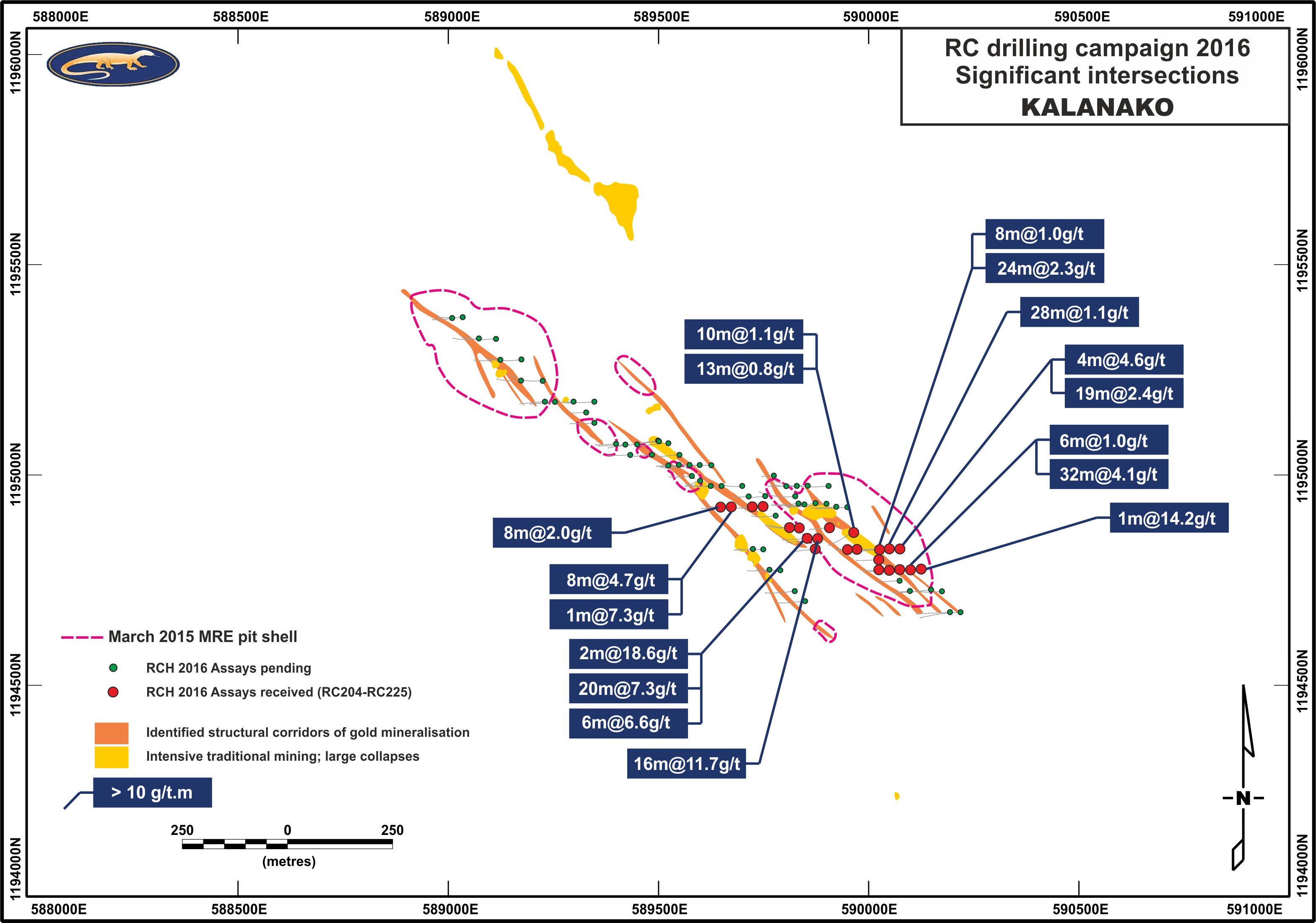
The results reported in this news release reflect the first batch of assays from 21 holes over 2,173m, from a total programme of 82 holes over 8,635m. This first batch represents nearly one-quarter of the total drill programme (holes RC204 to RC225). Maps of the general layout of the drill programme, the location of individual drill holes and significant intersections is provided in figures 1 and 2 near the end of this news release. Drill holes for the entire historical drill programme, including IAMGOLD's 2010 to 2012 and Avnel's 2016 drill programmes, and geophysical gradient IP are respectively presented in figures 2 and 3. Select composite assays and related drill hole information from this first batch is presented in the tables at the end of this news release.
The majority of the assays reported in this news release are from the South-East and Central-South zones of the deposit. Results reported in the existing MRE pit shells are encouraging and should support the conversion of a large part of the Inferred Resource into Measured or Indicated categories. High grade results reported outside the existing MRE pit shells provide a significant opportunity to improve known mineralisation into large portions of the bock model that were not classified as resources.
Significant intervals (>25g/t.m) from the South-East zone (inside the 2015 resources pit shells):
- KO-SOM-RC205 4.1 g/t Au over 32 m (EOH)
Including 40.8 g/t Au over 2 m
- KO-SOM-RC210 2.4 g/t Au over 19 m
Including 10.7 g/t Au over 1 m
- KO-SOM-RC211 1.1 g/t Au over 28 m
- KO-SOM-RC212 2.3 g/t Au over 24 m
Significant intervals (>25g/t.m) from the South-East zone (outside the 2015 resources pit shells):
- KO-SOM-RC216 11.7 g/t Au over 16 m
Including 166 g/t Au over 1 m
- KO-SOM-RC217 18.6 g/t Au over 2 m and 7.3 g/t Au over 20 m
Including 29.9 g/t Au over 3 m and 5.6 g/t Au over 6 m Including 27.1 g/t Au over 1 m
- KO-SOM-RC224 4.7 g/t Au over 8 m
Including 27.9 g/t Au over 1 m
A summary of select composite assays and drill hole information from the 2016 drilling campaign are presented in tables 1 and 2, respectively.
Kalanako Maiden Resource and Avnel's Drilling Programme Successfully Achieved in Q4 2016
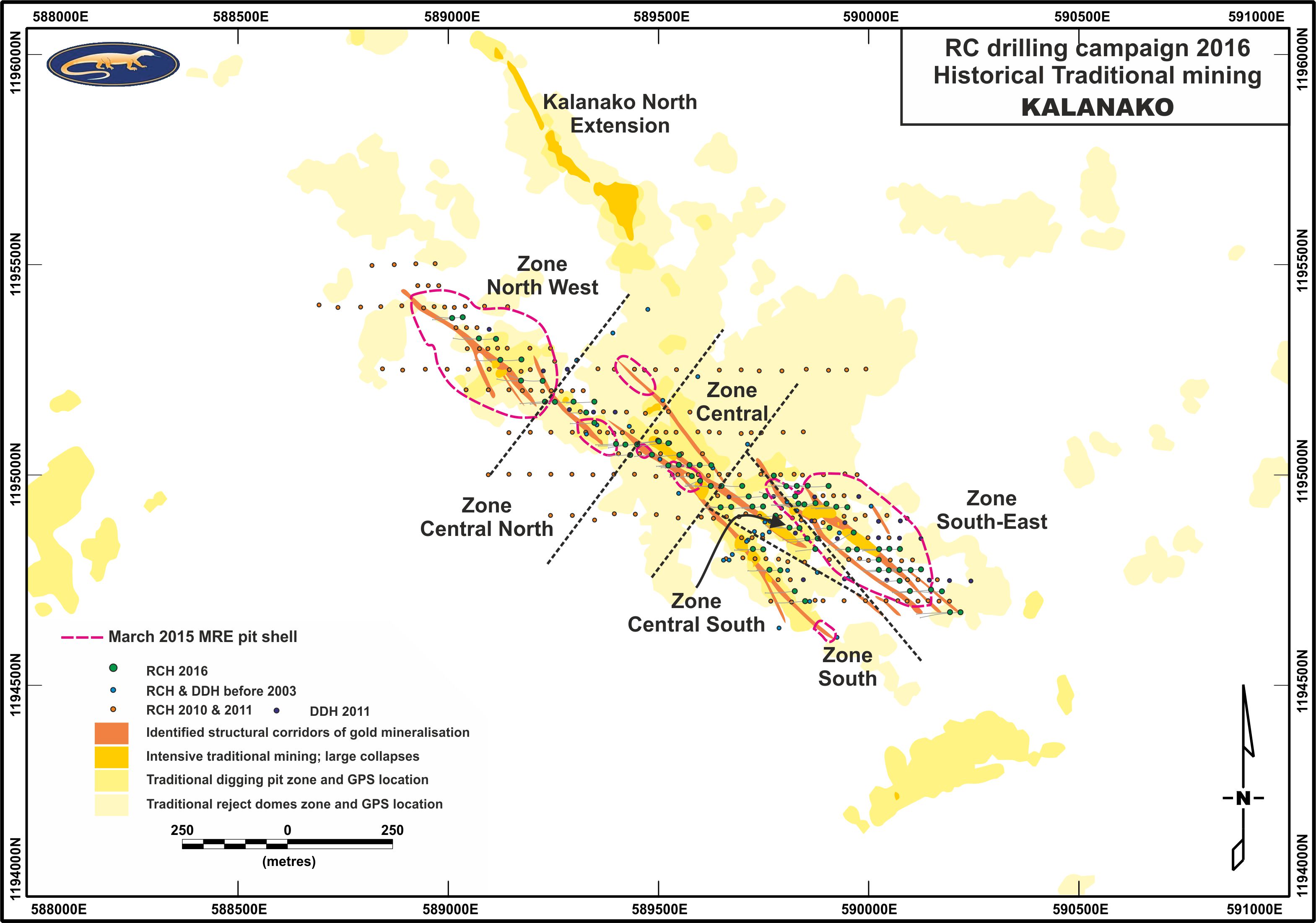
Located less than 3 km northeast of the Kalana Main Project and the milling facilities proposed in the OFS-DFS, the Kalanako prospect is an old area of traditional mining activity (Figure 2). Several mineralised trends have been established from RC and diamond drilling at Kalanako, resulting in a single northwest-southeast corridor of 1,500 meters by 250 meters. These mineralised zones are typically less than 10-20 meters wide and appear to be steeply dipping to the East, often contain high-grade intercepts near surface (i.e. in the weathered zone).
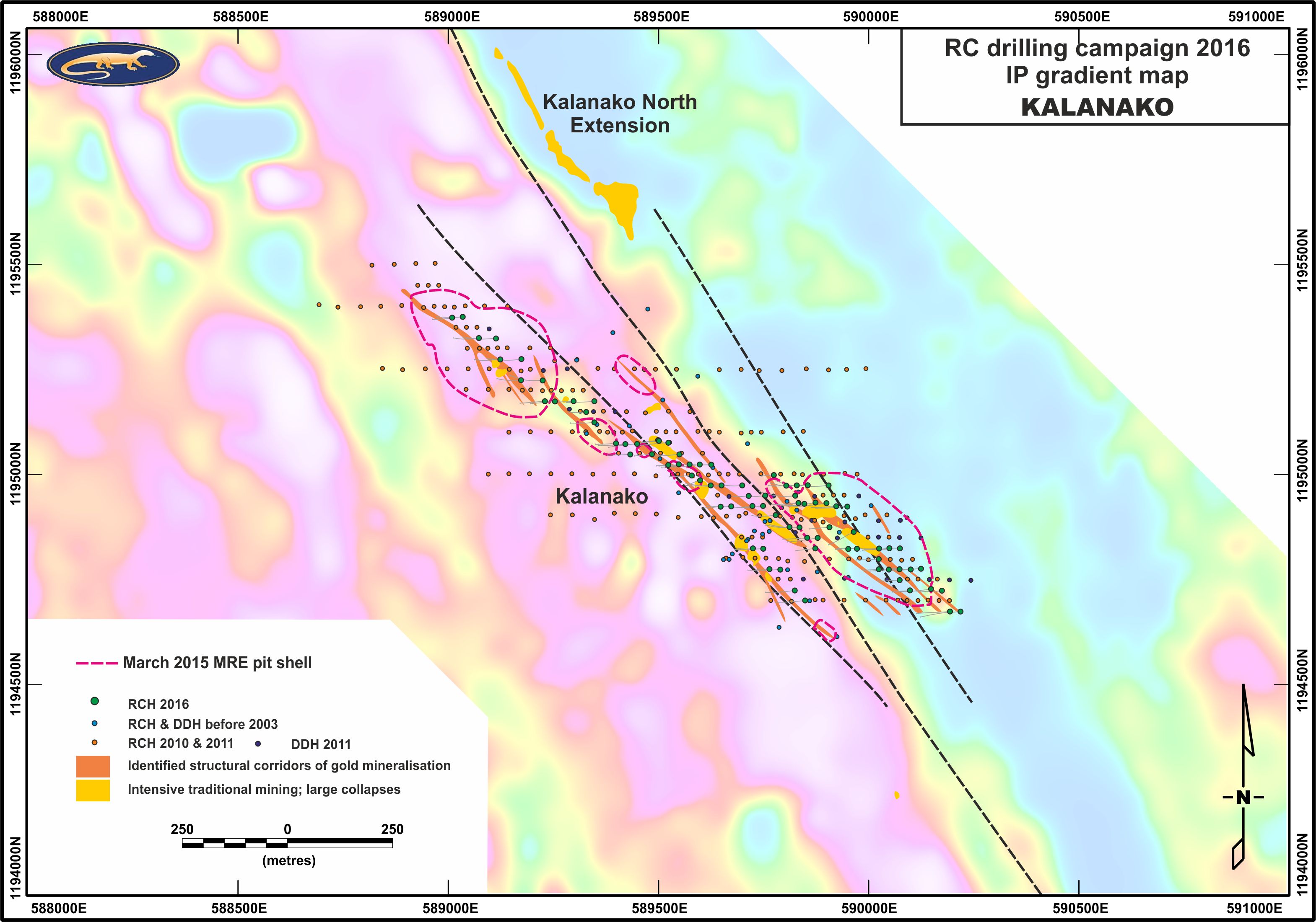
The depth of saprolite and saprock is between 70 m and 130 m, much deeper than that observed at the Kalana deposit. Diamond drilling at Kalanako intersected numerous high strain zones, packets of densely laminated quartz veins or vein stockwork with sulphides and locally highly altered and mineralised felsic intrusive rocks. Mineralisation is associated with these felsic intrusive rocks or quartz stockwork that occur along northwest-southeast striking shear zones, parallel or less than 10° in azimuth from the main IP boundary between a low and a high IP gradient domain (Figure 3).
The March 2015 MRE for the Kalanako deposit was based upon information from 46 diamond drill holes and 232 RC drillholes. Historical drill-hole intersection were independently summarised and press-released in October 2016. The Kalanako Mineral Resource Statement completed by Denny Jones (Pty) Limited, has been reported above a cut-off grade of 0.9 g/t Au, and is summarised as follow:
Inferred in-situ resource of 0.07 Moz (0.38 Mt grading 5.55 g/t Au)
An infill drilling programme of 8,635 meters has been successfully achieved in December 2016, on time and on budget and with an excellent productivity and safety record (no Lost Time Injury). This programme was focused on Kalanako's saprolite and saprock weathered domains, a depth considerably deeper than observed at Kalana Main (drillhole depth of 50-175 meters).
Targets of the Kalanako drilling campaign:
- Improve grade continuity infilling the in-pit resource to upgrade resource classification.
- Using historical data as a guide, drill the mineralised zones between these resource pits in order to increase the total amount of resources.
A large part of the Kalanako prospect remains undrilled. The drilled portion of Kalanako located at the central part of a 5 km long geophysical structure (figure 3) defined as a contact between low and high IP gradient domains. Kalanako is open on strike. Some large collapses above old artisanal underground developments in the north and more modern artisanal pits in the south, highlights the continuity of the mineralisation along the main northwest-southeast structure. Future drilling campaigns would target extensions along strike following our low-risk infill programme.
Corporate Exploration Strategy:
In addition to the resource defined at Kalana, we see significant potential to add satellite deposits on our existing permit.
A potential opportunity exists that would allow us to increase the production profile outlined in the DFS-OFS. The mill proposed in our DFS-OFS can process 25% more saprolite ore than fresh rock due to the relative ease of processing saprolite through the crushing and grinding circuit. In keeping with our corporate strategy, as we progress into construction we plan on continuing to add to the quantity and quality our mineral inventory through exploration work focusing on the soft saprolite high grade ore with the aim to increase planned gold production and reduce our total cash cost per ounce using satellite targets to supplement Kalana.
The high-grade and close proximity makes Kalanako our highest priority advanced stage exploration target. It has the potential to become a high-grade open-pit satellite deposit delivering additional ore to the operation proposed in the DFS-OFS. As a supplemental deposit to Kalana Main, Kalanako could help extend the mine life or increase average gold production.
Ongoing Geological Work Progressing Our Exploration Portfolio
As Avnel commences construction on Kalana Main we will be accelerating our regional geology programme to progress our portfolio of exploration targets. To date, only 3 of our 30 targets have been partially drill tested. Exploration work is being conducted to evaluate and rank our premier targets.
Exploration and QA/QC Programmes
Exploration programmes are conducted under the supervision of Dr. Olivier Féménias, EurGeol 1115, Avnel's Vice-President, Geology. Dr. Féménias, is a Qualified Person as defined by National Instrument 43-101 of the Canadian Securities Administrators. Strict sampling and QA/QC protocol are followed, including the insertion of standards, blanks, and duplicates on a regular basis as well as laboratory visit by senior geologists. Sample intervals are usually 1.0 m. Samples are prepared on site and collected by BIGS Global Burkina SARL ("BIGS Global") and transported to Ouagadougou in Burkina Faso for analysis. Analytical method is a 2-kilogram bottle-roll cyanidation using a LeachWELL catalyst. The leach residues from all samples with a grade in excess of 0.1 g/t Au were prepared by BIGS Global and split to 50 grams and then analysed by standard Fire Assay. Composites presented in the assay results tables include intervals with a grade x thickness equal or greater than 5 grams of gold per tonne x metre ("g/t.m") with a minimum grade of 0.65 g/t Au over a 1 m minimum width with a maximum internal dilution of 3 m. No assays results were capped. Due to the exploratory nature of this programme the true width of the mineralisation has not been reported. The intersections presented herein may not represent the true width of mineralisation.
About Avnel Gold
Avnel Gold is a TSX-listed gold mining, exploration and development company with operations in south-western Mali in West Africa. The Company's focus is to develop its 80%-owned Kalana Main Project from a small underground mine into a low-cost, open pit mining operation. The Company is also advancing exploration on several nearby satellite deposits on the 387 km2 30-year Kalana Exploitation Permit.
On January 9, 2017, the Company reported the results of an Optimized Feasibility Study ("OFS") prepared by Snowden Mining Industry Consultants. The OFS outlines an 18-year open-pit mine life at the Kalana Main Project recovering 1.82 million ounces of gold at an average "all-in sustaining cost" of $561 per ounce over the first five years of steady state production and $730 per ounce over the life of mine with an initial capital cost of $171 million. Utilising a gold price of $1,200 per ounce and a 5% discount rate, the DFS reported a net present value ("NPV") of $321 million after-tax and imputed interest, and an internal rate of return ("IRR") of 50% on a 100% project basis.
No stock exchange, securities commission or other regulatory authority has approved or disapproved the information contained in this news release.
CAUTIONARY STATEMENTS
Forward-Looking Statements
This news release includes certain "forward-looking statements". All statements, other than statements of historical fact, included in this release, including the future plans and objectives of Avnel Gold, are forward-looking statements that involve various risks and uncertainties. There can be no assurance that forward-looking statements will prove to be accurate and actual results and future events could differ materially from those anticipated in such statements. Important factors that could cause actual results to differ materially from Avnel Gold's expectations include, among others, risks related to international operations, the actual results of current exploration activities, conclusions of economic evaluations and changes in project parameters as plans continue to be refined as well as future prices of gold and silver, as well as those factors discussed in the section entitled "Risk Factors" in Avnel Gold's most recently completed Annual Information Form, which is available on SEDAR (www.sedar.com). Although Avnel Gold has attempted to identify important factors that could cause actual results to differ materially, there may be other factors that cause results not to be as anticipated, estimated or intended. There can be no assurance that such statements will prove to be accurate as actual results and future events could differ materially from those anticipated in such statements. Accordingly, readers should not place undue reliance on forward-looking statements.
Technical Information
Except where indicated, the disclosure contained or incorporated into this news release of an economic, scientific or technical nature, has been summarised or extracted from the National Instrument 43-101 - Standards of Disclosure for Mineral Projects("NI43-101") compliant technical report titled "NI43-101 Technical Report on Kalana Main Project", dated effective 30 March 2016 (the "Kalana Technical Report"), prepared by Snowden Mining Industry Consultants (Pty) Ltd. ("Snowden"), Denny Jones Ltd ("Denny Jones"), DRA Projects SA (Pty) Ltd ("DRA") and Epoch Resources (Pty) Ltd ("Epoch Resources"). The Kalana Technical Report was prepared under the supervision of Mr. Allan Earl (Executive Consultant - Mining Engineering of Snowden), Mr. Ivor Jones (Executive Consultant - Applied Geosciences of Denny Jones (Pty) Limited), Mr. Glenn Bezuidenhout (Principal Process Engineer of DRA), Mr. Sybrand van der Spuy (Civil Engineer of DRA), Mr. Guy Wiid (Principal Consultant -Tailings and Waste Rock Facilities of Epoch Resources), and Mr. Stephanus (Fanie) Coetzee (Principal Consultant -Environmental and Social of Epoch Resources), all of whom are independent "Qualified Persons" as such term is defined in NI 43-101. Readers should consult the Kalana Technical Report to obtain further particulars regarding the Kalana Project, which contains the Kalana Main Project, the Kalana Mine, plus a number of mineral exploration prospects. The Company filed the Kalana Technical Report in support of the Feasibility Study and the ESIA on SEDAR on May 6, 2016.
Table 1: Kalanako Drilling - Select Composite Intervals
Includes intervals >5 g/t.m, cut-of grade of 0.65 g/t Au, maximum 3m of internal dilution, no assay are capped
| Drill Hole ID | From (m) |
To (m) |
Interval (m) |
Grade (g/t Au) |
Metal (g/t.m) |
Comment | Zone | |||||||
| KO-SOM-RC204 | 43 | 44 | 1 | 14.17 | 14.2 | SE | ||||||||
| - | 108 | 135 | 27 | 0.78 | 21.0 | SE | ||||||||
| KO-SOM-RC205 | 48 | 54 | 6 | 1.01 | 6.1 | SE | ||||||||
| 58 | 90 | 32 | 4.06 | 129.8 | inc. 2m@40.8g/tEOH | SE | ||||||||
| KO-SOM-RC206 | No significant interval | SE | ||||||||||||
| KO-SOM-RC207 | No significant interval | SE | ||||||||||||
| KO-SOM-RC208 | No significant interval | SE | ||||||||||||
| KO-SOM-RC209 | No significant interval | SE | ||||||||||||
| KO-SOM-RC210 | 91 | 95 | 4 | 4.64 | 18.6 | inc. 1m@11.67g/t | SE | |||||||
| - | 99 | 118 | 19 | 2.42 | 46.0 | inc. 1m@10.73g/t | SE | |||||||
| KO-SOM-RC211 | 43 | 71 | 28 | 1.10 | 30.8 | SE | ||||||||
| KO-SOM-RC212 | 6 | 14 | 8 | 1.03 | 8.3 | SE | ||||||||
| 18 | 42 | 24 | 2.32 | 55.6 | SE | |||||||||
| KO-SOM-RC213 | No significant interval | SE | ||||||||||||
| KO-SOM-RC214 | No significant interval | SE | ||||||||||||
| KO-SOM-RC215 | No significant interval | Central S | ||||||||||||
| KO-SOM-RC216 | 70 | 86 | 16 | 11.70 | 187.2 | Central S | ||||||||
| KO-SOM-RC217 | 16 | 18 | 2 | 18.62 | 37.2 | Central S | ||||||||
| - | 50 | 70 | 20 | 7.26 | 145.2 | Central S | ||||||||
| - | 74 | 80 | 6 | 5.57 | 33.4 | Central S | ||||||||
| KO-SOM-RC218 | No significant interval | Central S | ||||||||||||
| KO-SOM-RC219 | 79 | 89 | 10 | 0.87 | 8.7 | Central S | ||||||||
| KO-SOM-RC220 | No significant interval | Central S | ||||||||||||
| KO-SOM-RC221 | 17 | 27 | 10 | 1.09 | 10.9 | SE | ||||||||
| - | 95 | 108 | 13 | 0.81 | 10.5 | SE | ||||||||
| KO-SOM-RC222 | No significant interval | Central S | ||||||||||||
| KO-SOM-RC223 | No significant interval | Central S | ||||||||||||
| KO-SOM-RC224 | 71 | 79 | 8 | 4.73 | 37.8 | Central | ||||||||
| 88 | 89 | 1 | 7.27 | 7.3 | Central | |||||||||
| KO-SOM-RC225 | 20 | 28 | 8 | 2.03 | 16.2 | Central |
- Due to the exploratory nature of this programme the true width of the mineralisation has not been reported, the intersections presented herein may not represent the true width of mineralisation.
- Numbers in bold represent intervals greater than 30 grams/tonne x metres (25 g/t.m)
- "BOH" denotes that the hole began in mineralisation
- "EOH" denotes that the hole ended in mineralisation
Table 2: Kalanako - Drill Hole Collar
| Hole ID | Easting (1) | Northing (1) | Length (m) | Dip (°) | Azimuth (°) | Type (2) | Section | ||||||
| KO-SOM-RC204 | 590125 | 1194777 | 144 | -55 | 265 | RCH | 4775 | ||||||
| KO-SOM-RC205 | 590100 | 1194775 | 90 | -55 | 265 | RCH | 4775 | ||||||
| KO-SOM-RC206 | 590074 | 1194776 | 105 | -55 | 265 | RCH | 4775 | ||||||
| KO-SOM-RC207 | 590049 | 1194775 | 85 | -55 | 265 | RCH | 4775 | ||||||
| KO-SOM-RC208 | 590024 | 1194776 | 67 | -55 | 265 | RCH | 4775 | ||||||
| KO-SOM-RC209 | 590024 | 1194800 | 91 | -55 | 265 | RCH | 4800 | ||||||
| KO-SOM-RC210 | 590074 | 1194825 | 145 | -55 | 265 | RCH | 4825 | ||||||
| KO-SOM-RC211 | 590049 | 1194825 | 109 | -55 | 265 | RCH | 4825 | ||||||
| KO-SOM-RC212 | 590024 | 1194825 | 130 | -55 | 265 | RCH | 4825 | ||||||
| KO-SOM-RC213 | 589973 | 1194825 | 85 | -55 | 265 | RCH | 4825 | ||||||
| KO-SOM-RC214 | 589950 | 1194825 | 50 | -55 | 265 | RCH | 4825 | ||||||
| KO-SOM-RC215 | 589874 | 1194825 | 79 | -55 | 265 | RCH | 4825 | ||||||
| KO-SOM-RC216 | 589879 | 1194850 | 120 | -55 | 265 | RCH | 4850 | ||||||
| KO-SOM-RC217 | 589854 | 1194850 | 100 | -55 | 265 | RCH | 4850 | ||||||
| KO-SOM-RC218 | 589812 | 1194876 | 109 | -55 | 265 | RCH | 4875 | ||||||
| KO-SOM-RC219 | 589835 | 1194875 | 121 | -55 | 265 | RCH | 4875 | ||||||
| KO-SOM-RC220 | 589907 | 1194875 | 85 | -55 | 265 | RCH | 4875 | ||||||
| KO-SOM-RC221 | 589964 | 1194865 | 121 | -55 | 244 | RCH | 4875 | ||||||
| KO-SOM-RC222 | 589748 | 1194926 | 91 | -55 | 265 | RCH | 4925 | ||||||
| KO-SOM-RC223 | 589723 | 1194926 | 85 | -55 | 265 | RCH | 4925 | ||||||
| KO-SOM-RC224 | 589673 | 1194925 | 100 | -55 | 265 | RCH | 4925 | ||||||
| KO-SOM-RC225 | 589648 | 1194925 | 76 | -55 | 265 | RCH | 4925 |
- Collar coordinates in UTM Zone 29 WGS84 surveyed using a DGPS
- RCH = reverse circulation drill hole
To view Figure 1: Kalanako mineralisations, 2016 campaign drilling pattern and batch 1 significant intercepts (>5g/t.m), please visit the following link: http://media3.marketwire.com/docs/Significant%20intersections.jpg
To view Figure 2: Kalanako mineralisations, drilling pattern, maiden resource pit shells and Historical Traditional mining footprint, please visit the following link: http://media3.marketwire.com/docs/Historical%20traditional.jpg
To view Figure 3: Induced Polarisation (IP) gradient map highlighting the structural location of the Kalanako prospect and the area drilled to date, please visit the following link: http://media3.marketwire.com/docs/IP%20gradient.jpg
Contact Information:
Howard Miller
Chairman and CEO
+44 207 589 9082 or UK Mobile: +44 7768 696129
Canadian Mobile: +1 (416) 726 8174
howard@hbmiller.co.uk
Avnel Gold Mining Limited
Ian McDonald
Vice-President, Corporate Development
+1 647 407 2515
imcdonald@avnelgold.com
www.avnelgold.com