VANCOUVER, BRITISH COLUMBIA--(Marketwire - Aug. 4, 2011) - Gold Canyon Resources Inc. (TSX VENTURE:GCU)(PINK SHEETS:GDCRF) ("Gold Canyon" or "the Company") is pleased to announce hole SP11-066 intersected 24 meters at 17.48 grams per tonne gold (79 feet at 0.510 oz per ton gold) including 6 meters at 52.60 grams per tonne gold (20 feet at 1.536 oz per ton gold) at its 100% controlled Springpole Gold Project, located 110 kilometers northeast of the Red Lake Mining Camp, Ontario, Canada.
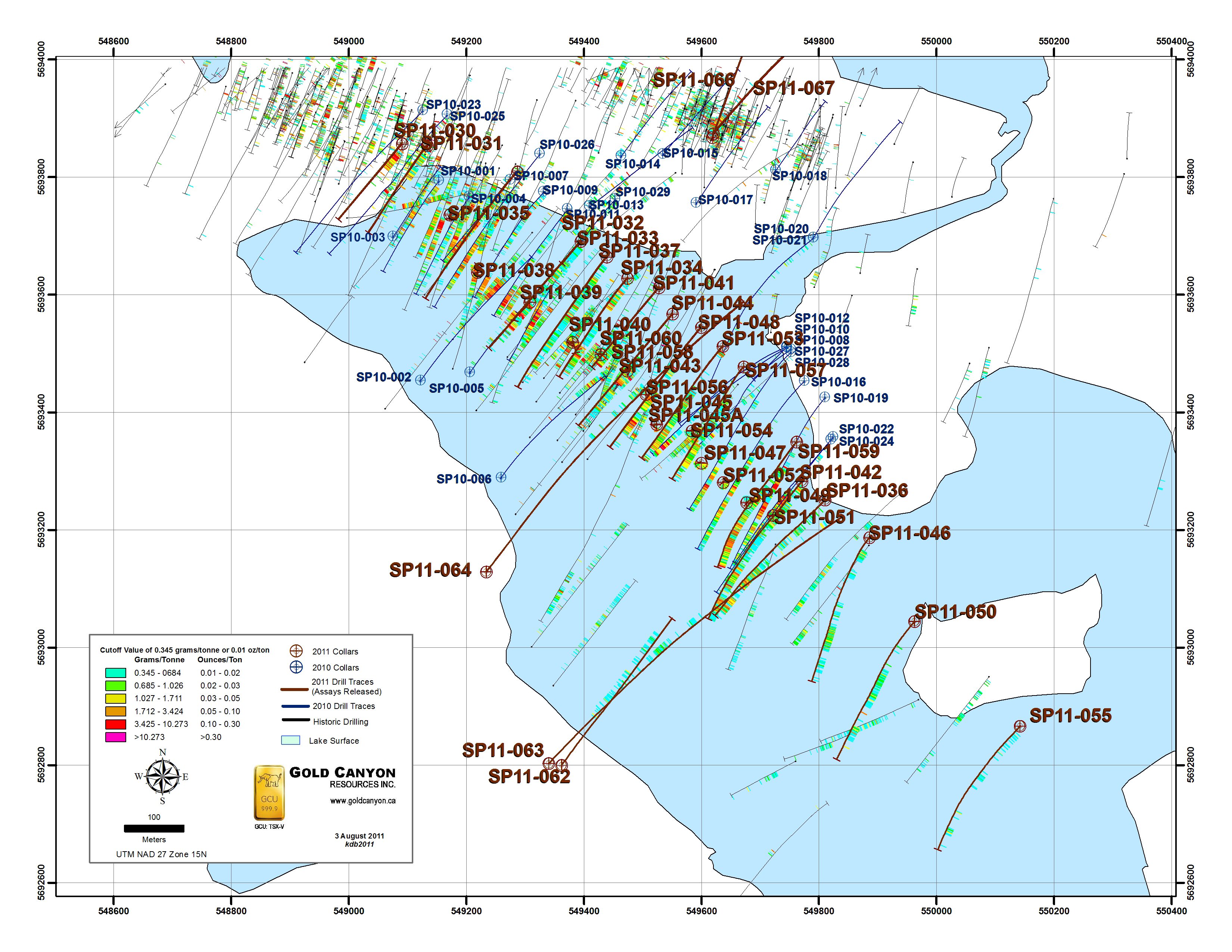
To view associated map, visit the following link: http://media3.marketwire.com/docs/DrillMapGCU.jpg
- Diamond drill hole SP11-066 intersected 24 meters at 17.48 grams per tonne gold (79 feet at 0.510 oz per ton gold) including 6 meters at 52.60 grams per tonne gold (20 feet at 1.536 oz per ton gold). Applying a 1 oz per ton (34.29 grams per tonne) top cut, these intervals are 24 meters at 10.31 grams per tonne gold (79 feet at 0.301 oz per ton gold) including 6 meters at 29.45 grams per tonne gold (20 feet at 0.859 oz per ton gold). This hole was collared along the southwest margin of the East Extension Zone and drilled at an azimuth of 020 degrees true north with a –45 degree inclination. Remaining un-assayed core from this hole will be submitted for metallurgical testing to characterize ore from the East Extension Zone.
- Diamond drill hole SP11-067 intersected 39 meters at 2.93 grams per tonne gold (128 feet at 0.086 oz per ton gold) including 1 meter at 39.73 grams per tonne gold (3 feet at 1.160 oz per ton gold). This hole was collared from the same pad as SP11-066, but was drilled at an azimuth of 040 degrees true north with a –45 degree inclination.
- Holes SP11-066 and -067 tested an area where historic drill holes reportedly encountered similar mineralization. Some nearby historic holes were selectively sampled and, in several cases, core is now missing from these holes. Holes SP11-066 and -067 confirm results in this area; they also demonstrate overall better continuity of mineralization when compared to historic data and will be used for future resource calculations.
"We are very pleased to confirm high grades at shallow depth in the East Extension Zone," states Dr. Quinton Hennigh, Technical Advisor to and Director of Gold Canyon. "Although East Extension is a smaller target than the Portage Zone, it could potentially make a good starter pit. Holes SP11-066 and -067 demonstrate good continuity of high-grade mineralization along the southwest margin of this deposit. These results coupled with the corridor of near-surface mineralization that we discovered in drilling between the Portage Zone and East Extension last summer suggest we might ultimately be able to connect these two deposits."
| Summary of Results from SP11-066 and -067 | |||||||||
| Hole | From (meters) |
To (meters) |
Length (meters) |
Gold (grams per tonne) |
Gold (grams per tonne) – top cut to 34.29 gpt |
Length (feet) |
Gold (oz per ton) |
Gold (oz per ton) – top cut to 1 opt |
|
| SP11-066 | 16.0 | 40.0 | 24.0 | 17.48 | 10.31 | 79 | 0.510 | 0.301 | |
| includes | 22.0 | 23.0 | 1.0 | 67.54 | 34.29 | 3 | 1.972 | 1.000 | |
| includes | 30.0 | 36.0 | 6.0 | 52.60 | 29.45 | 20 | 1.536 | 0.859 | |
| includes | 34.0 | 35.0 | 1.0 | 117.94 | 34.29 | 3 | 3.444 | 1.000 | |
| SP11-067 | 15.0 | 54.0 | 39.0 | 2.93 | 2.79 | 128 | 0.086 | 0.081 | |
| includes | 41.0 | 42.0 | 1.0 | 39.73 | 34.29 | 3 | 1.160 | 1.000 | |
| 105.0 | 109.0 | 4.0 | 2.03 | NA | 13 | 0.059 | NA | ||
| Weighted averages were used to calculate all reported intervals | |||||||||
| Reported intervals apply a 0.2 gram per tonne gold (0.006 oz per ton gold) lower cutoff | |||||||||
| Internal dilution within reported intervals does not exceed core lengths of 2 meters. | |||||||||
| 1 troy oz = 31.103 grams | |||||||||
| Conversion factor ‐ grams per tonne to troy oz per short ton; g/t divided by 34.2857 or g/t multiplied by 0.0292 | |||||||||
| 1 meter = 3.28 feet | |||||||||
- Diamond drill hole SP11-064 was drilled from the southwest shore of Springpole Bay on the +300 section at an azimuth of 040 degrees true north and an inclination of -45 degrees. This hole encountered numerous intervals of gold and silver mineralization as well as typical Portage Zone style alteration, but appears to have followed the southwest margin of the zone.
- Based on 3-dimensional and geostatistical modelling of the results of SP11-064 and other recent drill holes, it is now believed that the Portage Zone dips moderately to steeply northeast as opposed to southwest as previously believed. Holes SP11-070 and -071, part of the summer-fall 2011 drill program, and both currently in progress, are drilled from the northeast shore of Springpole Lake, adjacent to camp, toward the southwest, and are designed to better test this newly interpreted geometry. The results from both holes will be included in future resource calculations.
| Summary of Results from SP11-064 | ||||||||||
| Hole | From (meters) |
To (meters) |
Length (meters) |
Gold (grams per tonne) |
Silver (grams per tonne) |
Length (feet) |
Gold (oz per ton) |
Silver (oz per ton) |
Silver- to-Gold Ratio |
|
| SP11-064 | 61.0 | 63.0 | 2.0 | 4.20 | 78.00 | 7 | 0.123 | 2.278 | 18.6 | |
| 154.0 | 156.0 | 2.0 | 1.26 | 42.80 | 7 | 0.037 | 1.250 | 34.0 | ||
| 263.0 | 264.0 | 1.0 | 1.82 | 34.90 | 3 | 0.053 | 1.019 | 19.2 | ||
| 407.0 | 415.0 | 8.0 | 0.51 | 3.71 | 26 | 0.015 | 0.108 | 7.3 | ||
| 439.0 | 444.0 | 5.0 | 0.74 | 4.46 | 16 | 0.022 | 0.130 | 6.0 | ||
| 479.0 | 489.0 | 10.0 | 0.41 | 0.88 | 33 | 0.012 | 0.026 | 2.1 | ||
| 510.0 | 514.0 | 4.0 | 0.44 | 0.65 | 13 | 0.013 | 0.019 | 1.5 | ||
| 535.0 | 561.0 | 26.0 | 0.40 | 1.31 | 85 | 0.012 | 0.038 | 3.3 | ||
| 571.0 | 576.0 | 5.0 | 0.39 | 3.95 | 16 | 0.011 | 0.115 | 10.1 | ||
| 627.5 | 633.5 | 6.0 | 0.39 | 2.18 | 20 | 0.011 | 0.064 | 5.6 | ||
| Weighted averages were used to calculate all reported intervals | ||||||||||
| Reported intervals apply a 0.2 gram per tonne gold (0.006 oz per ton gold) lower cutoff | ||||||||||
| Internal dilution within reported intervals does not exceed core lengths of 2 meters. | ||||||||||
| 1 troy oz = 31.103 grams | ||||||||||
| Conversion factor ‐ grams per tonne to troy oz per short ton; g/t divided by 34.2857 or g/t multiplied by 0.0292 | ||||||||||
| 1 meter = 3.28 feet | ||||||||||
Holes SP11-061, -065 -069, all recently completed core holes, will be assayed later in the year when they undergo an extensive series of metallurgical tests.
Operational Update
On August 1, a medium lift helicopter mounted drills on each of the two barges currently on-site at Springpole. Availability of a suitable helicopter to lift the drills onto the barges has been hampered by the need of such aircraft to help fight extensive forest fires that have erupted in NW Ontario since early July. Due to this and other fire related issues, the Company's summer drill program has experienced slower core production than planned. Dry and warm weather conditions persist and the Springpole base camp remains on high alert.
Two land-based drills have operated continuously at Springpole since late June. These rigs are currently drilling holes SP11-070 and -071, both tests of the Portage Zone drilled from the northeast shore of Springpole Lake. In addition, four metallurgical holes have recently been completed and will undergo an extensive series of metallurgical tests to be run over the next several months. With the barge drills operational, the Company plans to keep four drills operating through freeze-up, likely in early November. These rigs should produce around 9,000 meters of core, which is less than the 12,000 meters that was originally planned. Holes drilled this summer are expected to allow the Company to revise the 43-101 compliant resource estimate for the deposit sometime late in the second half of 2011.
About Springpole
Springpole is an alkaline intrusion hosting a gold system that represents a potentially new style of Canadian Archean Shield gold deposit. The Portage zone is hosted by a trachytic porphyry intrusion displaying polyphase autolithic breccias that host gold mineralization. Other zones, including the East Extension, Camp and Main, consist of high-grade veins and pods hosted in diatreme breccias composed of intrusive and country rock fragments. These breccias surround the northwest and northern margins of the Portage Zone. The known mineralized zones underlie a total area of about 4 square kilometers representing only about 15 percent of the greater alkaline intrusive complex which remains yet to be explored.
Core was logged then split using diamond saws with one half sent for analyses and the other half stored for future reference. Quality control programs include the use of field and laboratory duplicates, standards, blanks, and internal and external check assaying. Certified sample standards were submitted with the normal sample stream. Gold and silver assays were completed by SGS Canada Inc. in Red Lake and Toronto, Ontario using a 30 gram charge, fire assay, with an ICP finish. For over limit assay results, initial assays in excess of 10.0 grams per tonne Au, a gravimetric finish is utilized.
Quinton Hennigh, Ph.D., P.Geo. and Alan Roberts, M.Sc., P.Geo. are the Qualified Persons pursuant to National Instrument 43-101 responsible for, and have reviewed and approved, the technical information contained in this news release. Dr. Hennigh is acting as a technical adviser to Gold Canyon and Alan Roberts is the Senior Geologist of Alaska Earth Sciences, Inc. and Project Manager at Springpole.
About Gold Canyon Resources Inc.:
Gold Canyon is engaged in the acquisition and exploration of mineral and precious metals properties. The Company controls a 100% interest in the Springpole Gold - Horseshoe Island Gold, Platinum, Palladium Project and Favourable Lake Poly-metallic property currently under option to Guyana Frontier Mining Corp. pursuant to an option and joint venture agreement entered into in December 2005 - all in the Red Lake Mining District of Ontario, Canada.
Through its wholly owned U.S. subsidiary, Gold Canyon Resources USA Inc., the Company controls a 100% interest in the Cordero Gallium Project situated in Humboldt County, Nevada, U.S.A.
Gold Canyon entered into a Joint Exploration Agreement with the Japan Oil, Gas and Metals National Corporation (JOGMEC) in January 2009.
Additional information can be found on the Company's website: www.goldcanyon.ca
Akiko Levinson,
President & Director
Certain statements contained in this news release using the terms "may", "expects to", "project", "estimate", "plans", and other terms denoting future possibilities, are forward-looking statements in respect to various issues including upcoming events based upon current expectations which involve risks and uncertainties that could cause actual outcomes and results to differ materially. The future conduct of the Company's business and the feasibility of its mineral exploration properties are dependent upon a number of factors and there can be no assurance that the Company will be able to conduct its operations as contemplated and the accuracy of these statements cannot be guaranteed as they are subject to a variety of risks that are beyond our ability to predict or control and which may cause actual results to differ materially from the projections or estimates contained herein. The risks include, but are not limited to, the risks described in the above press release; those risks set out in the company's disclosure documents and its annual, quarterly and current reports; the fact that exploration activities seldom result in the discovery of a commercially viable mineral resource and are also significant amounts of capital to undertake and the other risks associated with start-up mineral exploration operations with insufficient liquidity, and no historical profitability. The Company disclaims any obligation to revise any forward looking statements as a result of information received after the fact or regarding future events.
Neither the TSX Venture Exchange nor its Regulation Services Provider (as that term is defined in the policies of the TSX Venture Exchange) accepts responsibility for the adequacy or accuracy of this news release.
Contact Information:
(604) 682-3234 or Toll free: 1 (888) 242-3234
(604) 682-0537 (FAX)
info@goldcanyon.ca
Gold Canyon Resources Inc.
Leo Karabelas
Investor Relations
(416) 543-3120
leo@frontlineir.com
www.goldcanyon.ca