CALGARY, ALBERTA--(Marketwired - May 26, 2016) - Goldbelt Empires Limited (TSX VENTURE:GBE) (the "Company" or "Goldbelt Empires") announced today the results of a recently concluded high-resolution, property-wide airborne magnetic and gamma-ray geophysical survey ("Airborne Survey") and the interpretation of the resulting data sets at its flagship South Morila gold concession area in Mali, West Africa.
Highlights
A review of the geophysical survey, and its subsequent structural interpretation, has yielded the following findings and identified a number of compelling geophysical targets:
- Several previously undetected major potassium anomalies that pose compelling targets
- Previously known mineralized sites now deemed high-priority prospects, in consequence of their enhanced attractiveness in the context of the new geophysical data set
- Multiple high potential targets will be the focus of a recommended campaign of scout drilling, as part of the company's Phase II exploration program.
The Company retained Momentum Group to interpret the geophysical data sets obtained by the Airborne Survey, and Momentum Group provided the Company with its interpretation in its report dated 10 May 2016 ("Report"). The section captioned Summary (below) sets out the main findings of the Report. Andrew Dacey, a member of the Momentum Group, is the primary author of the Report; Andrew Dacey also serves as Technical Adviser to the Company.
Jonathan Challis, CEO of Goldbelt Empires, commented: "These results are a testament to the tremendous potential of the South Morila concession and the competence of the Company's technical team. The geophysical survey and interpretation cap the successful results of our 2015-2016 Phase I exploration program. We are delighted with the findings and look forward to Phase II of our exploration program involving geochemical work and scout drilling over the main targets."
Jonathan Challis (C.Eng & FIMMM), CEO of Goldbelt Empires, and Andrew Dacey (R.P.Geo & FIMMM), its technical advisor, are the Qualified Persons, as defined by National Instrument 43-101, who have approved the scientific and technical information, and verified the data except where otherwise noted, in this news release.
SUMMARY:
GEOLOGICAL INTERPRETATION & TARGET IDENTIFICATION
The geophysical data sets from the Airborne Survey, collected and processed by New Resolution Graphics in late 2015 and early 2016 for Goldbelt Empires, was integrated by Momentum Group with existing geology, geochemistry and mineral occurrence data (pre-dating the Company's acquisition of the South Morila concession area).
Prior exploration from 2000-12 was based on the historical (wide spaced, lower resolution) SYSMIN regional geophysical survey completed in 2001-2004 for the Ministry of Mines of Mali, covering most of the known Birimian terrains, including the South Morila concession area.
Goldbelt's newly acquired (high resolution) geophysics are a significant advance.
Relevant findings from the Report prepared by Momentum Group include:
- The Radiometric data analysis shows several major potassium anomalies previously undetected that are strongly indicative of potential alteration targets. Potassium anomalies are commonly associated with gold occurrences in Birimian terrains.
- Analysis of the aeromagnetic data shows three distinct structural and lithological domains:
- a structurally complex northern zone showing a number of northeast trending structures along with a series of northwest trending features, possibly representing dikes or sills,
- a central, likely, metasedimentary zone, and
- a southern zone thought to comprise dominantly of metasediments and intrusives.
- The geophysical data provides further confirmation of the presence of similar rocks/alteration that are associated with major discoveries in the region, thereby increasing the attractiveness of certain targets within the exploration area.
- The geophysical data show two intrusive bodies of exceptional interest given regional exploration success associated with intrusives.
- A much-improved understanding of the overall structural regime including the significance of major features that may control the extent and possible orientation of previously identified mineralization.
The Report's findings are further described in the figures and discussion below in the sections captioned: Interpretation - Maps of New Data Sets; Interpretation - Magnetics; Interpretation - Radiometrics; Target Identification - Revealed Features & Anomalies; and Recommendations for Further Exploration.
The Report has identified a number of Targets and has made several Recommendations for further exploration including selective geochemistry and a scout drilling program.
Interpretation - Maps of New Data Sets
The Report prepared by Momentum Group interpreted the new data sets recently acquired in the Airborne Survey (2015-2016). For comparison reference is made to the historical geophysical survey (2001-2004).
New Aeromagnetic Data. Areas of folding and structural complexity add depth to the geological understanding.
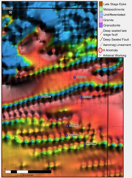
See Figure 1 (Historical Magnetics Analytic Signal, Regional Data) and Figure 2 (New Magnetics Analytic Signal Goldbelt Data).
To view Figure 1, click on the following link: http://media3.marketwire.com/docs/GoldbeltEmpireImage1May26.jpg
To view Figure 2, click on the following link: http://media3.marketwire.com/docs/GoldbeltEmpireImage2May26.jpg
New Radiometric data. The new radiometric data reveals potassium ano malies not previously identified.
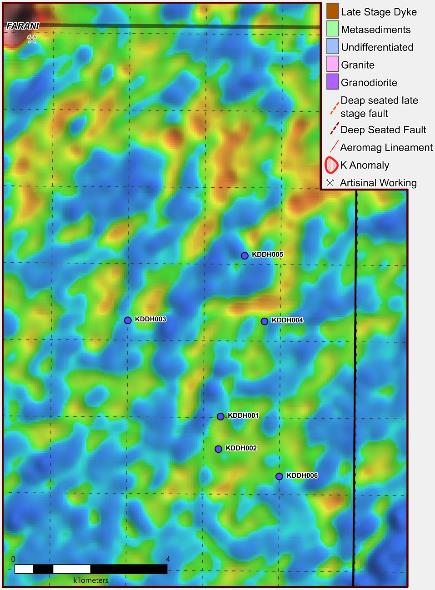
See Figure 3 (Historical Potassium Radiometrics, Regional Data) and Figure 4 (New Potassium Radiometrics Goldbelt Data).
To view Figure 3, click on the following link: http://media3.marketwire.com/docs/GoldbeltEmpireImage3May26.jpg
To view Figure 4, click on the following link: http://media3.marketwire.com/docs/GoldbeltEmpireImage4May26.jpg
Interpretation - Magnetics
The Report found that the most dominant feature identified from the geophysical survey is a series of east-west trending magnetic highs which are interpreted to represent late stage dykes. These are common throughout Birimian terrains and have no relationship with or are known to host any mineralisation of interest.
Northern Zone
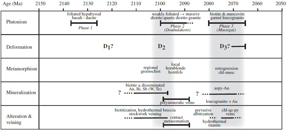
A highly variable magnetic northern zone is thought to represent a suite of biotite rich leucogranites and muscovite-biotite granites and pegmatites. These distinct pink-weathered granitic batholiths are often referred to as Massigui type. They are predominantly coarse grained, equigranular, and massive, although porphyritic varieties are also locally encountered throughout the region. These intrusions represent the youngest episode of plutonism in the area. Less common for a granite, they are moderately to highly magnetic.
In the northwest of the licence a magnetic low area is thought to represent a granodiorite intrusion. Outcropping granodiorites just outside of the licence area have been recorded and are common in the area. At Morila, intrusions such as the Doubalakoro pluton have been identified, they are coarse-grained, massive, and equigranular, with magnesio-hornblende and biotite as the main ferromagnesian phenocrysts. They are interpreted to be syn-tectonic with D2, the main mineralisation event at Morila.
See Figure 5 (Timing and paragenitic relationship between magmatism, deformation, metamorphism, mineralisation and alteration at the Morila Deposit).
To view Figure 5, click on the following link: http://media3.marketwire.com/docs/GoldbeltEmpireImage5May26.jpg
Central and Southern Zone
These are two areas characterised by a low magnetic signature and likely represent zones of metasediments and probable intrusions. Drilling by AngloGold Exploration Mali ("AngloGold") as well as Randgold support this. The geology of the area is not thought to be straightforward, rather it is likely highly folded with numerous diorite, granite and minor leucogranite intrusions.
The central zone is likely represented by metasediments with minor intrusives. It has a low magnetic signature and is thought to be regionally folded with a NW fold axis. It is similar metasediments to these that host the Morila mine and which were the focus for all of AngloGold's and Randgold's exploration efforts.
Regional geology suggests that the very low magnetic signature identified in the south of the licence may actually be due to the presence of the Bougouni Granite, a massive granite-gneissic pluton that is thought to be older than potential mineralisation in the area and represent basement.
Interpretation - Radiometrics
The Report found distinct potassium signatures in several locations within the South Morila concession area that were previously undetected. The primary measurement from the radiometrics of interest is the potassium signature.
A potassium signature essentially comes from K feldspar, predominantly micas such as muscovite and biotite, which is common in the felsic regolith of the metasediments and are low in mafic rocks. While it is also found extensively around intrusive bodies, such as the granodiorite in the northwest of the licence area, it is strongly related to Birimian type alteration of host rocks. As such each potassium signature is a good indicator of a target for further follow up.
Two very strong potassium anomalies have been identified along with a number of lessor but still important anomalous zones. An important consideration to take into account is that a false positive of a potassium anomaly often arises from residual potassium in river beds and areas of sheet wash; such false positives are clearly evident in the historical potassium radiometric map (2001-2004 geophysical survey).
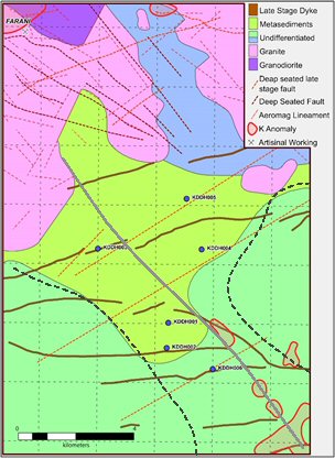
Target Identification - Revealed Features & Anomalies
The Report examined a number of features and anomalies (Fig. 6 and 7), and has identified a number of targets ("Targets") for further exploration (Fig. 7):
To view Figure 6, click on the following link: http://media3.marketwire.com/docs/GoldbeltEmpireImage6May26.jpg
To view Figure 7, click on the following link: http://media3.marketwire.com/docs/GoldbeltEmpireImage7May26.jpg
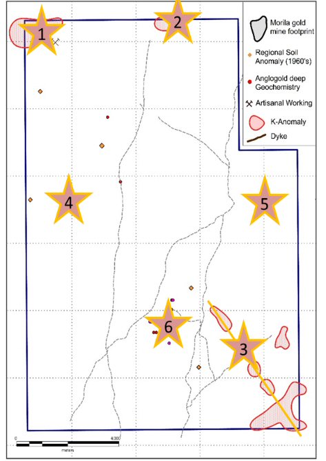
- Farani Prospect: a potassium anomaly in the NW corner of the license area marked by a large granite intrusion and artisanal workings.
- Northern Line Prospect: a potassium anomaly on the northern boundary line of the license area.
- Syinsorola Trend: a cluster of potassium anomalies in the SE, possibly oriented along NW trending structure.
- Boufala Prospect: historical geochemical anomalies identified in the 1960s by regional soil sampling undertaken by and for the Government of Mali, several lineaments identified from the high-resolution geophysics intersect in the immediate vicinity.
- Mena Prospect: an area of gold mineralization identified in 1960s by historical regional soil sampling undertaken for the Government of Mali.
- K3SX Prospect: anomalies identified through AngloGold's shallow RAB holes. Randgold completed DDH drilling included 1.4 g/t over 3 meters. The Company's Airborne Survey (2015-2016) magnetics show structural complexity within the low responsive sediments.
References to the exploration conducted by AngloGold and Randgold (item 6) are discussed in the Company's 43-101 Technical Report dated December 14, 2014 available at the Company's SEDAR profile. References to the results of the historical regional soil sampling (items 4 and 5) and the prior exploration (item 6), are based on data not independently verified by the Company or the Qualified Persons who have approved this news release.
Recommendations for Further Exploration
The Report prepared by the Momentum Group recommended the following steps be taken to advance the exploration programme ("Recommendations"):
- Ground checking of anomalies.
- Further satellite imagery analysis.
- Regional geochemistry; "filling in the holes" - targeting the anomalies identified which are not covered by either AngloGold's or Randgold's previous exploration. To include both an orientation multi-element geochemical survey (soil & shallow RAB) followed by a detailed geochemical survey over 3 or 4 of the most promising targets.
- Trial MMI survey line over the Randgold area of drilling.
- Scout drilling programme over the most prospective anomalies identified, 1st stage RC and DDH exploration (3,000m / 25 holes / 100-150m deep)
About Goldbelt Empires
Goldbelt Empires is a gold explorer focused on the West African Goldbelt, and listed its shares on the TSX Venture Exchange in October 2015. Its flagship property is the South Morila gold concession in the Republic of Mali. The South Morila concession covers an area approximately 150 km2 in size, and is located in the southern part of Mali approximately 250 km southeast of the capital of Bamako.
Additional Information on Goldbelt Empires Ltd.
For more information on the business and property of the Company, readers are referred to the Company's Final Prospectus dated September 22, 2015, available at the Company's SEDAR profile at www.SEDAR.com.
This press release contains forward-looking information. More particularly, this press release contains statements concerning the results of the airborne survey and the conclusions in respect of the geophysical properties and trends of the South Morila gold concession drawn after processing such results, the use of such geophysical information by the Company, the identification of potential field reconnaissance, and the recommended steps be taken to advance the Company's exploration programme. Although the Company believes in light of the experience of its officers and directors, current conditions and expected future developments and other factors that have been considered appropriate, that the expectations reflected in this forward-looking information are reasonable, undue reliance should not be placed on them because the Company can give no assurance that they will prove to be correct.
Forward looking information involves known and unknown risks, uncertainties, assumptions (including, but not limited to, assumptions on the performance and financial results of the properties of the Company and certain other risks detailed from time to time in the Company's public disclosure documents including, without limitation, those risks identified in the Final Prospectus which is available on the Company's SEDAR profile at www.sedar.com) and other factors that may cause actual results or events to differ materially from those anticipated in such forward-looking information. The forward-looking statements contained in this press release are made as of the date hereof and the Company undertakes no obligations to update publicly or revise any forward-looking statements or information, whether as a result of new information, future events or otherwise, unless so required by applicable securities laws.
This press release is not an offer of the securities for sale in the United States. The securities have not been registered under the U.S. Securities Act of 1933, as amended, and may not be offered or sold in the United States absent registration or an exemption from registration. This press release shall not constitute an offer to sell or the solicitation of an offer to buy nor shall there be any sale of the securities in any state in which such offer, solicitation or sale would be unlawful.
Neither the TSX Venture Exchange nor its Regulation Services Provider (as that term is defined in the policies of the TSX Venture Exchange) accepts responsibility for the adequacy or accuracy of this press release.
Contact Information:
Jonathan Challis
Chief Executive Officer and Director
United Kingdom
+44 (78) 4120-2386
Goldbelt Empires Limited
Victor Dusik
Chief Financial Officer and Director
Executive Corporate Secretary
Canada
+1 (604) 818-4100