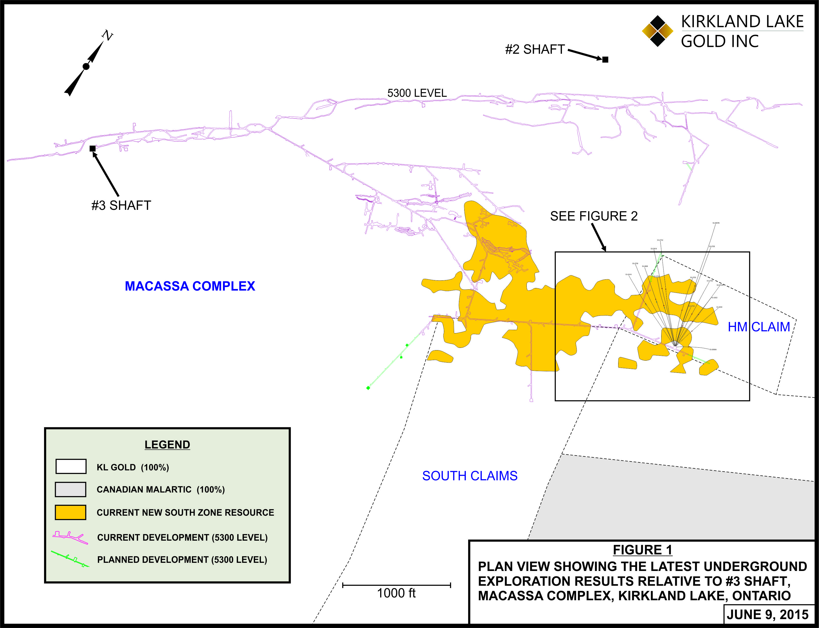
TORONTO, ONTARIO--(Marketwired - June 9, 2015) - Kirkland Lake Gold Inc. (TSX:KGI)(AIM:KGI), ("KL Gold" or the "Company") an operating and exploration gold company provides an update on the underground exploration drilling program on the South Mine Complex ("SMC") at the Company's Macassa Mine Complex, and in particular on the HM claim (formerly a part of the Queenston Mining Joint Venture property).
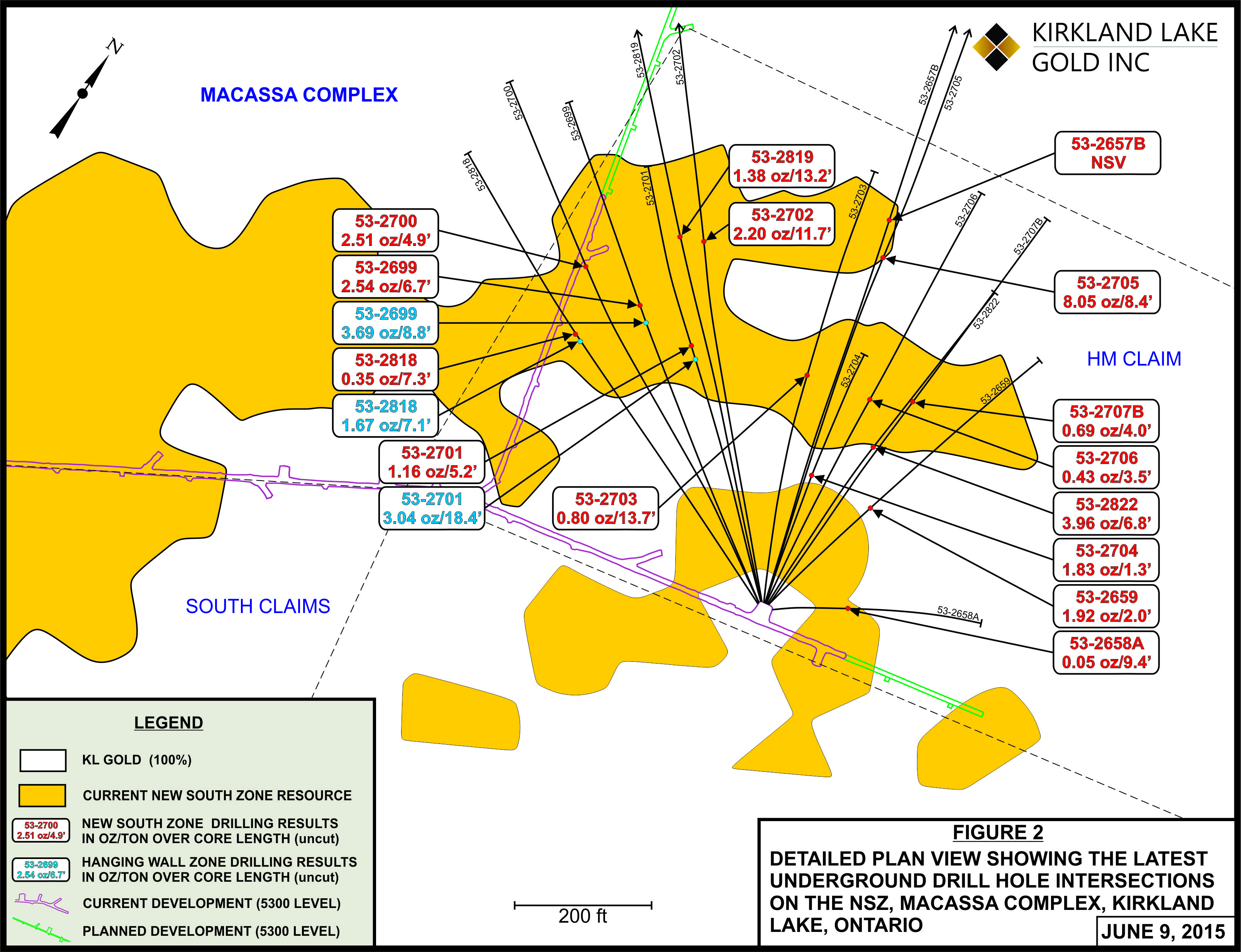
The HM claim, located approximately 2,000 feet (610 metres) southeast of the #2 shaft at the Macassa Mine Complex, is an area that hosts the easterly strike of the SMC. The drilling program tested inferred resource blocks within a larger combined indicated and inferred resource area as well as along the fringe areas targeting the New South Zone ("NSZ") and a parallel Hanging Wall Zone ("HWZ").
Highlights:
- NSZ extended 89 feet (27.1 metres) down dip from previous intersections.
- Drill hole 53-2705 returned 8.05 ounces per ton ("opt") uncut (5.02 opt cut), or 276.0 grams per tonne ("g/t") uncut, (172.1 g/t cut) over a true width of 6.7 feet (2.0 metres).
- Drill hole 53-2822 returned 3.96 opt uncut (3.46 opt cut), or 135.8 g/t uncut, (118.6 g/t cut) over a true width of 6.4 feet (2.0m).
- NSZ extended 105 feet (32.0 metres) up dip and 53 feet (16.2 metres) east from previous intersections.
- Drill hole 53-2704 returned 1.83 opt, or 62.7 g/t (no cutting factor applied), over a true width of 1.3 feet (0.4 metres).
- Drill hole 53-2659 returned 1.92 opt, or 65.8 g/t (no cutting factor applied), over a true width of 1.9 feet (0.6 metres).
- Three new intersections on the HWZ help define the zone over a strike length of 200 feet (60.1 metres), with a 100 foot (30.5 metres) dip component.
- Drill hole 53-2699 returned 3.69 opt uncut (2.17 opt cut), or 126.5 g/t uncut (74.4 g/t cut), over a true width of 7.0 feet (2.1 metres).
- Drill hole 53-2701 returned 3.04 opt uncut (1.18 opt cut), or 104.2 g/t uncut (40.5 g/t cut), over a true width 15.8 feet (4.8 metres).
- Drill hole 53-2818 returned 1.67 opt uncut (1.30 opt cut), or 57.2 g/t uncut (44.6 g/t cut), over a true width of 6.0 feet (1.8 metres).
Notes: Higher grade assays are cut to 7.20 opt (246.9 g/t) and 3.50 opt (120.0 g/t), depending on location within the zone (see tables below for more information).
Mr. George Ogilvie, Chief Executive Officer of the Company commented, "Since acquiring the properties associated with the Queenston Joint Venture in August of 2012, we have seen tremendous exploration success, particularly on the South Claims. In April of this year we reported 49,000 ounces of probable reserves (40,000 tons at an average grade of 1.23 opt or 42.2 g/t). As well, we announced an increase in indicated resources on the South Claims by 35%, and an increase in inferred resources by 19%, year over year. We are encouraged by these results and look forward to the possibility of expanding as well as improving our confidence of resources onto the HM Claim that remains open to the east."
"Since the Company commenced exploration activities, we have focussed on exploration associated with the Macassa Mine Complex which includes areas near the old Macassa Mine and the South Mine Complex. We now look to expand our exploration efforts and embark upon a regional program to test the four contiguous properties that lie to the east, with an initial investment of C$1.5 million, to be carried out during calendar 2015. We strongly believe in the robust nature of this camp, and our potential to extend our life of mine through organic growth."
SMC Underground Drilling on the HM Claim
The initial phase of drilling was spaced at an average of 120 foot (36.6 metre) intersections, while the infill drilling conducted recently has reduced the intersections to an average of 50 to 80 feet (15.2 metres to 24.4 metres) within the existing resource blocks.
Of the ten drill holes testing the NSZ inferred resource areas, and within the existing resource area, nine holes returned intersections which will make the minimum requirements to calculate an indicated resource (which is updated annually). Based on the conversion of the inferred resources to an indicated resource level, this represents a conversion rate of approximately 90%.
Of the five drill holes testing the NSZ inferred resources along the fringe areas of the current resource area, four returned intersections which will make the minimum requirements to calculate an indicated resource (which is updated annually). Based on the conversion of the inferred resources to an indicated resource level in these areas, this represents a conversion rate of approximately 80%, and is expected to expand the dip and strike components of the current resource blocks.
The following figures, referred to elsewhere in this release, may be viewed at the Company's website at www.klgold.com.
- Figure 1 – PLAN VIEW showing the latest underground exploration results relative to #3 shaft: http://media3.marketwire.com/docs/1471m1.jpg
- Figure 2 – DETAILED PLAN VIEW showing the latest drill hole intersections on the NSZ: http://media3.marketwire.com/docs/1471m2.jpg
The following table summarize the latest underground drilling results in imperial values:
SMC UNDERGROUND EXPLORATION – Imperial Table (5300 Level)
| DRILL HOLE | ZONE | DIP (degrees) | AZIMUTH (degrees) | FROM (feet) | TO (feet) | CORE LENGTH (feet) | TRUE WIDTH (feet) | ASSAY (oz/ton) | CUT (oz/ton) |
| 53-2657B | NSZ | -36 | 345 | 739.5 | 740.5 | 1.0 | N/C | NSV | - |
| 53-2658A | NSZ | -79 | 049 | 572.8 | 582.2 | 9.4 | N/C | 0.05 | - |
| 53-2659 | NSZ | -70 | 008 | 591.8 | 593.8 | 2.0 | 1.9 | 1.92, VG | - |
| 53-2699 | HWZ | 628.5 | 637.3 | 8.8 | 7.0 | 3.69 | 2.17** | ||
| Including | 628.5 | 630.2 | 1.7 | 1.3 | 6.09 | - | |||
| And | 630.2 | 632.5 | 2.3 | 1.8 | 7.41, VG, Tell | - | |||
| And | -47 | 302 | 632.5 | 634.3 | 1.8 | 1.4 | 1.51 | - | |
| NSZ | 666.0 | 672.7 | 6.7 | 5.1 | 2.54 | - | |||
| Including | 666.0 | 668.0 | 2.0 | 1.5 | 3.18, VG, Tell | - | |||
| And | 668.0 | 669.6 | 1.6 | 1.2 | 2.75, VG | - | |||
| And | 669.6 | 670.9 | 1.3 | 1.0 | 3.43, VG, Tell | - | |||
| 53-2700 | NSZ | 728.2 | 733.1 | 4.9 | 3.5 | 2.51 | - | ||
| Including | -42 | 302 | 728.2 | 729.4 | 1.2 | 0.9 | 6.85, VG, Tell | - | |
| And | 729.4 | 730.4 | 1.0 | 0.7 | 2.89, VG | - | |||
| 53-2701 | HWZ | 578.8 | 597.2 | 18.4 | 15.8 | 3.04 | 1.18** | ||
| Including | 586.8 | 588.4 | 1.6 | 1.4 | 17.36, VG, Tell | -- | |||
| And | 591.8 | 593.8 | 2.0 | 1.7 | 9.04, VG, Tell | - | |||
| And | -52 | 313 | 595.7 | 597.2 | 1.5 | 1.3 | 4.15, VG | - | |
| NSZ | 619.3 | 624.5 | 5.2 | 4.3 | 1.16 | - | |||
| Including | 620.3 | 622.2 | 1.9 | 1.6 | 1.69, VG | - | |||
| And | 622.2 | 624.5 | 2.3 | 1.9 | 1.11 | - | |||
| 53-2702 | NSZ | 708.3 | 720.0 | 11.7 | 8.5 | 2.20 | - | ||
| Including | 708.3 | 709.8 | 1.5 | 1.1 | 7.26, VG | - | |||
| And | -42 | 320 | 709.8 | 710.9 | 1.1 | 0.8 | 2.16 | - | |
| And | 710.9 | 713.0 | 2.1 | 1.5 | 3.92, VG | - | |||
| And | 716.1 | 717.6 | 1.5 | 1.1 | 1.17, VG | - | |||
| And | 717.6 | 718.7 | 1.1 | 0.8 | 1.11, VG | - | |||
| 53-2703 | NSZ | 573.0 | 586.7 | 13.7 | 12.1 | 0.80 | - | ||
| Including | -55 | 333 | 576.3 | 577.9 | 1.6 | 1.4 | 1.19 | - | |
| And | 577.9 | 580.7 | 2.8 | 2.5 | 2.35, VG, Tell | - | |||
| 53-2704 | NSZ | -69 | 341 | 569.1 | 570.4 | 1.3 | 1.3 | 1.83, Tell | - |
| 53-2705 | NSZ | 713.8 | 722.2 | 8.4 | 6.7 | 8.05 | 5.02* | ||
| Including | -45 | 344 | 715.5 | 717.4 | 1.9 | 1.5 | 3.70 | - | |
| And | 717.4 | 720.0 | 2.6 | 2.1 | 13.98, VG, Tell | - | |||
| And | 720.0 | 722.2 | 2.2 | 1.8 | 12.48, VG, Tell | - | |||
| 53-2706 | NSZ | -54 | 350 | 599.0 | 602.5 | 3.5 | 3.3 | 0.43 | - |
| 53-2707B | NSZ | -54 | 006 | 632.6 | 636.6 | 4.0 | 3.6 | 0.69 | - |
| Including | 632.6 | 633.9 | 1.3 | 1.2 | 1.29, Tell | - | |||
| 53-2818 | HWZ | 655.1 | 662.2 | 7.1 | 6.0 | 1.67 | 1.30** | ||
| Including | -45 | 292 | 655.1 | 656.2 | 1.1 | 0.9 | 5.90, VG | - | |
| And | 658.9 | 660.0 | 1.1 | 0.9 | 2.33 | - | |||
| NSZ | 672.7 | 680.0 | 7.3 | 5.7 | 0.35 | - | |||
| 53-2819 | NSZ | 720.7 | 733.9 | 13.2 | 10.7 | 1.38 | - | ||
| Including | -41 | 313 | 724.8 | 725.8 | 1.0 | 0.8 | 1.36 | - | |
| And | 725.8 | 727.2 | 1.4 | 1.1 | 6.33, VG | - | |||
| And | 730.0 | 732.7 | 2.7 | 2.2 | 1.70 | - | |||
| 53-2822 | NSZ | 602.6 | 609.4 | 6.8 | 6.4 | 3.96 | 3.46* | ||
| Including | -62 | 358 | 602.6 | 604.6 | 2.0 | 1.9 | 3.66, VG, Tell | ||
| And | 604.6 | 606.5 | 1.9 | 1.8 | 8.96, VG, Tell | ||||
| And | 606.5 | 607.7 | 1.2 | 1.1 | 1.81, VG |
| VG = Visible Gold; Tell = Tellurides; *Cut = cut to 7.20 opt, **Cut = cut to 3.50 opt. |
| NSZ = New South Zone; HWZ = Hanging Wall Zone, True Width N/C = True width not calculated, will not make minimum requirements for resource definition. The estimation methodology for the calculation of mineral resources are included within the NI 43-101 technical report (see "Technical Information"). |
The following table summarizes the latest underground drilling results in metric values:
SMC UNDERGROUND EXPLORATION - Metric Table (5300 Level)
| DRILL HOLE | ZONE | DIP (degrees) | AZIMUTH (degrees) | FROM (m) | TO (m) | CORE LENGTH (m) | TRUE WIDTH (m) | ASSAY (g/t) | CUT (g/t) |
| 53-2657B | NSZ | -36 | 345 | 225.4 | 225.7 | 0.3 | N/C | NSV | - |
| 53-2658A | NSZ | -79 | 049 | 174.6 | 177.5 | 2.9 | N/C | 1.7 | - |
| 53-2659 | NSZ | -70 | 008 | 180.4 | 181.0 | 0.6 | 0.6 | 65.8, VG | - |
| 53-2699 | HWZ | 191.6 | 194.2 | 2.6 | 2.1 | 126.5 | 74.4** | ||
| Including | 191.6 | 192.1 | 0.5 | 0.4 | 208.8 | - | |||
| And | 192.1 | 192.8 | 0.7 | 0.5 | 254.1, VG Tell | - | |||
| And | -47 | 302 | 192.8 | 193.3 | 0.5 | 0.4 | 51.8 | - | |
| NSZ | 203.0 | 205.0 | 2.0 | 1.6 | 87.1 | - | |||
| Including | 203.0 | 203.6 | 0.6 | 0.5 | 109.0, VG, Tell | - | |||
| And | 203.6 | 204.1 | 0.5 | 0.4 | 94.3, VG | - | |||
| And | 204.1 | 204.5 | 0.4 | 0.3 | 117.6, VG Tell | - | |||
| 53-2700 | NSZ | 222.0 | 223.4 | 1.4 | 1.1 | 86.1 | - | ||
| Including | -42 | 302 | 222.0 | 222.3 | 0.3 | 0.3 | 234.9, VG, Tell | - | |
| And | 222.3 | 222.6 | 0.6 | 0.2 | 99.1, VG | - | |||
| 53-2701 | HWZ | 176.4 | 182.0 | 5.6 | 4.8 | 104.2 | 40.5** | ||
| Including | 178.9 | 179.3 | 0.4 | 0.4 | 595.2, VG, Tell | - | |||
| And | 180.4 | 181.0 | 0.6 | 0.5 | 309.9, VG, Tell | - | |||
| And | -52 | 313 | 181.6 | 182.0 | 0.4 | 0.4 | 142.3, VG | - | |
| NSZ | 188.8 | 190.3 | 1.5 | 1.3 | 39.8 | - | |||
| Including | 189.1 | 189.6 | 0.5 | 0.5 | 57.9, VG | - | |||
| And | 189.6 | 190.3 | 0.7 | 0.6 | 38.1 | - | |||
| 53-2702 | NSZ | 215.9 | 219.5 | 3.6 | 2.6 | 75.4 | - | ||
| Including | 215.9 | 216.3 | 0.4 | 0.3 | 248.9, VG | - | |||
| And | -42 | 320 | 216.3 | 216.7 | 0.4 | 0.2 | 74.1 | - | |
| And | 216.7 | 217.3 | 0.6 | 0.5 | 134.4, VG | - | |||
| And | 218.3 | 218.7 | 0.4 | 0.3 | 40.1, VG | - | |||
| And | 218.7 | 219.1 | 0.4 | 0.2 | 38.1, VG | - | |||
| 53-2703 | NSZ | 174.7 | 178.8 | 4.1 | 3.7 | 27.4 | - | ||
| Including | -55 | 333 | 175.7 | 176.1 | 0.4 | 0.4 | 40.8 | - | |
| And | 176.1 | 177.0 | 0.9 | 0.8 | 80.6, VG, Tell | - | |||
| 53-2704 | NSZ | -69 | 341 | 173.5 | 173.9 | 0.4 | 0.4 | 62.7, Tell | - |
| 53-2705 | NSZ | 215.9 | 220.1 | 4.2 | 2.0 | 276.0 | 172.1* | ||
| Including | -45 | 344 | 218.1 | 218.7 | 0.6 | 0.5 | 126.9 | - | |
| And | 218.7 | 219.5 | 0.8 | 0.6 | 479.3, VG, Tell | - | |||
| And | 219.5 | 220.1 | 0.6 | 0.5 | 427.9 VG, Tell | - | |||
| 53-2706 | NSZ | -54 | 350 | 182.6 | 183.6 | 1.0 | 1.0 | 14.7 | - |
| 53-2707B | NSZ | -54 | 006 | 192.8 | 194.0 | 1.2 | 1.1 | 23.7 | - |
| Including | 192.8 | 193.2 | 0.4 | 0.4 | 44.2, Tell | - | |||
| 53-2818 | HWZ | 199.7 | 201.8 | 2.1 | 1.8 | 57.3 | 44.6** | ||
| Including | -45 | 292 | 199.7 | 200.0 | 0.3 | 0.3 | 202.3, VG | - | |
| And | 200.8 | 201.2 | 0.4 | 0.3 | 79.9 | - | |||
| NSZ | 205.0 | 207.3 | 2.3 | 1.7 | 12.0 | - | |||
| 53-2819 | NSZ | 219.7 | 223.7 | 4.0 | 3.3 | 47.3 | - | ||
| Including | -41 | 313 | 220.9 | 221.2 | 0.3 | 0.2 | 46.6 | - | |
| And | 221.2 | 221.7 | 0.5 | 0.3 | 217.0, VG | - | |||
| And | 222.5 | 223.3 | 0.8 | 0.7 | 58.3 | - | |||
| 53-2822 | NSZ | 183.7 | 185.7 | 2.0 | 2.0 | 135.8 | 118.6* | ||
| Including | -62 | 358 | 183.7 | 184.3 | 0.6 | 0.6 | 125.5, VG, Tell | ||
| And | 184.3 | 184.9 | 0.6 | 0.5 | 307.2, VG, Tell | ||||
| And | 184.9 | 185.2 | 0.3 | 0.3 | 62.1, VG |
| VG = Visible Gold; Tell = Tellurides; *Cut = cut to 246.9 g/t, **Cut = cut to 120.0 g/t. |
| NSZ = New South Zone; HWZ = Hanging Wall Zone; True Width N/C = True width not calculated, will not make minimum requirements for resource definition. The estimation methodology for the calculation of mineral resources are included within the NI 43-101 technical report (see "Technical Information"). |
Qualified Person
The results of the Company's underground diamond drilling program have been reviewed, verified (including sampling, analytical and test data) and compiled by the Company's geological staff under the supervision of Mr. Stewart Carmichael, P.Geo., Manager of Exploration. Mr. Carmichael is the 'qualified person' for the purpose of National Instrument 43-101, Standards of Disclosure for Mineral Projects, of the Canadian Securities Administrators, and has reviewed and approved this news release.
QA/QC Controls
The Company has implemented a quality assurance and control (QA/QC) program to ensure sampling and analysis of all exploration work is conducted in accordance with the best possible practices. The drill core is sawn in half with one half of the core samples shipped to Swastika Laboratories in Swastika, Ontario. The other half of the core is retained for future assay verification. Other QA/QC includes the insertion of blanks, and the regular re-assaying of pulps and rejects at alternate certified labs. Gold analysis is conducted by fire assay using atomic absorption or gravimetric finish. The laboratory re-assays at least 10% of all samples and additional checks may be run on anomalous values.
Technical Information
The Company's Macassa Mine Property is the subject of a technical report prepared by Glenn R. Clark, P.Eng., titled Review of Resources and Reserves of Macassa Mine, Kirkland Lake, Ontario at January 1, 2015, dated May 22, 2015, which has been filed on SEDAR (www.sedar.com).
About the Company
Kirkland Lake Gold's corporate goal is to create a self-sustaining and long-lived intermediate gold mining company based in the historic Kirkland Lake Gold Camp. The Company plans to do this by mining to the reserve grade, generating profits and free cash flow for the shareholders. The Company will also look to take advantage of its increased infrastructure capacity in the appropriate gold price environment. At the same time, the Company is committed to maintaining a significant exploration program aimed at developing and maintaining a property wide reserve and resource base sufficient to sustain a mine life of more than ten years.
Over the last several years the Company has invested significant capital to improve the infrastructure of the business including upgrading the production hoist, skips, mill, underground mobile equipment and capital development. From initial discovery to present day there have been over 24 million ounces of gold mined from the Kirkland Lake camp while the current reserve and resource provides for potentially 14 years of mining with significant exploration upside.
Neither the Toronto Stock Exchange nor the AIM Market of the London Stock Exchange has reviewed or accepts responsibility for the adequacy or accuracy of this news release.
Cautionary Note Regarding Forward Looking Statements
This Press Release contains statements which constitute "forward-looking statements", including statements regarding the plans, intentions, beliefs and current expectations of the Company with respect to the future business activities and operating performance of the Company. The words "may", "would", "could", "should", "will", "intend", "plan", "anticipate", "believe", "estimate", "expect" and similar expressions, as they relate to the Company, are intended to identify such forward-looking statements.
Forward-looking statements used in this Press Release include, but may not be limited to, statements regarding the Company's exploration efforts including underground drilling being conducted at the SMC and the results thereof. The inclusion of these results into the annual mineral reserve and resource statements and any possible increase in the Company's level of resources and reserves. Investors are cautioned that forward-looking statements are based on the opinions, assumptions and estimates of management considered reasonable at the date the statements are made such as, without limitation, opinion, assumptions and estimates of management regarding the Company's business, its ability to increase its production capacity and decrease its production cost. Such opinions, assumptions and estimates, are inherently subject to a variety of risks and uncertainties and other known and unknown factors that could cause actual events or results to differ materially from those projected in the forward-looking statements. These factors include the Company's expectations in connection with the projects and exploration programs being met, the impact of general business and economic conditions, global liquidity and credit availability on the timing of cash flows and the values of assets and liabilities based on projected future conditions, fluctuating gold prices, currency exchange rates (such as the Canadian dollar versus the United States Dollar), possible variations in ore grade or recovery rates, changes in accounting policies, changes in the Company's corporate mineral resources, changes in project parameters as plans continue to be refined, changes in project development, construction, production and commissioning time frames, risks related to joint venture operations, the possibility of project cost overruns or unanticipated costs and expenses, higher prices for fuel, power, labour and other consumables contributing to higher costs and general risks of the mining industry, failure of plant, equipment or processes to operate as anticipated, unexpected changes in mine life, seasonality and unanticipated weather changes, costs and timing of the development of new deposits, success of exploration activities, permitting time lines, government regulation of mining operations, environmental risks, unanticipated reclamation expenses, title disputes or claims, and limitations on insurance, as well as those risk factors discussed or referred to in the Company's annual Management's Discussion and Analysis and Annual Information Form for the year ended April 30, 2014, and the Company's Management's Discussion and Analysis for the interim period ended January 31, 2015, filed with the securities regulatory authorities in certain provinces of Canada and available at www.sedar.com.
Should one or more of these risks or uncertainties materialize, or should assumptions underlying the forward-looking statements prove incorrect, actual results may vary materially from those described herein as intended, planned, anticipated, believed, estimated or expected. Although the Company has attempted to identify important risks, uncertainties and factors which could cause actual results to differ materially, there may be others that cause results not to be as anticipated, estimated or intended. The Company does not intend, and does not assume any obligation, to update these forward-looking statements except as otherwise required by applicable law.
Glossary of Terms
National Instrument 43-101 Definitions of Resources and Reserves
The Reserve and Resource estimation classifications as prescribed in National Instrument 43-101 are given here for clarity.
Mineral Resource
Mineral Resources are sub-divided into 3 categories depending on the geological confidence. The highest level with the most confidence is the 'Measured' category. The next level of confidence is the 'Indicated' category and the lowest level, or the resource with the least confidence, is the 'Inferred' category.
Inferred Mineral Resource
An 'Inferred Mineral Resource' is that part of a Mineral Resource for which quantity and grade or quality can be estimated on the basis of geological evidence and limited sampling and reasonably assumed, but not verified, geological and grade continuity. The estimate is based on limited information and sampling, gathered through appropriate techniques from locations such as outcrops, trenches, pits, workings and drill holes.
Indicated Mineral Resource
An 'Indicated Mineral Resource' is that part of a Mineral Resource for which quantity, grade or quality, densities, shape and physical characteristics, can be estimated with a level of confidence sufficient to allow the appropriate application of technical and economic parameters, to support mine planning and evaluation of the economic viability of the deposit. The estimate is based on detailed and reliable exploration and testing information gathered through appropriate techniques from locations such as outcrops, trenches, pits, workings and drill holes that are spaced closely enough for geological and grade continuity to be reasonably assumed.
Measured Mineral Resource
A 'Measured Mineral Resource' is that part of a Mineral resource for which quantity, grade or quality, densities, shape and physical characteristics are so well established that they can be estimated with confidence sufficient to allow the appropriate application of technical and economic parameters, to support production planning and evaluation of the economic viability of the deposit. The estimate is based on detailed and reliable exploration, sampling and testing information gathered through appropriate techniques from locations such as outcrops, trenches, pits, workings and drill holes that are spaced closely enough to confirm both geological and grade continuity.
Mineral Reserve
Mineral Reserves are sub-divided into 2 categories. The highest level of Reserves or the level with the most confidence is the 'Proven' category and the lower level of confidence of the Reserves is the 'Probable' category. Reserves are distinguished from resources as all of the technical and economic parameters have been applied and the estimated grade and tonnage of the resources should closely approximate the actual results of mining. The guidelines state
"Minerals Reserves are inclusive of the diluting material that will be mined in conjunction with the Mineral Reserve and delivered to the treatment plant or equivalent facility." The guidelines also state that, "The term 'Mineral Reserve' need not necessarily signify that extraction facilities are in place or operative or that all government approvals have been received. It does signify that there are reasonable expectations of such approvals."
Probable Mineral Reserve
A 'Probable Mineral Reserve' is the economically mineable part of an Indicated and in some circumstances a Measured Mineral Resource demonstrated by a least a Preliminary Feasibility Study. This study must include adequate information on mining, processing, metallurgical, economic, and other relevant factors that demonstrate, at the time of reporting, that economic extraction can be justified.
Proven Mineral Reserve
A 'Proven Mineral Reserve' is the economically mineable part of a Measured Mineral Resource demonstrated by at least a Preliminary Feasibility Study. This study must include adequate information on mining, processing, metallurgical, economic, and other relevant factors that demonstrate, at the time of reporting, that economic extraction is justified.
A more detailed list of technical terms can be found at http://klgold.com/cmsAssets/docs/pdfs/2013/2013%20Annual%20Information%20Form.pdf
Contact Information:
George Ogilvie, P.Eng
CEO
+1 709 532 5716
gogilvie@klgold.com
Kirkland Lake Gold Inc.
Suzette N Ramcharan, CPIR
Director of Investor Relations
+1 647-284-5315
sramcharan@klgold.com
www.klgold.com
NOMAD: Panmure Gordon (UK) Limited
Dominic Morley / Adam James
+44 (0) 20 7886 2500
Blytheweigh
Tim Blythe/Halimah Hussain/Camilla Horsfall
+44 (0) 20 7138 3204