KIRKLAND LAKE, ONTARIO--(Marketwired - June 18, 2013) - Kirkland Lake Gold Inc. (TSX:KGI)(AIM:KGI) (the Company), an operating and exploration gold company, is pleased to announce drilling results from its ongoing surface diamond drilling exploration program. This latest program included further drilling utilizing two drill rigs on the South Claims property (formerly held under a joint venture with Queenston Mining Inc. but which was acquired, along with the HM, North Amalgamated and other joint venture properties, from Queenston on August 30, 2012).
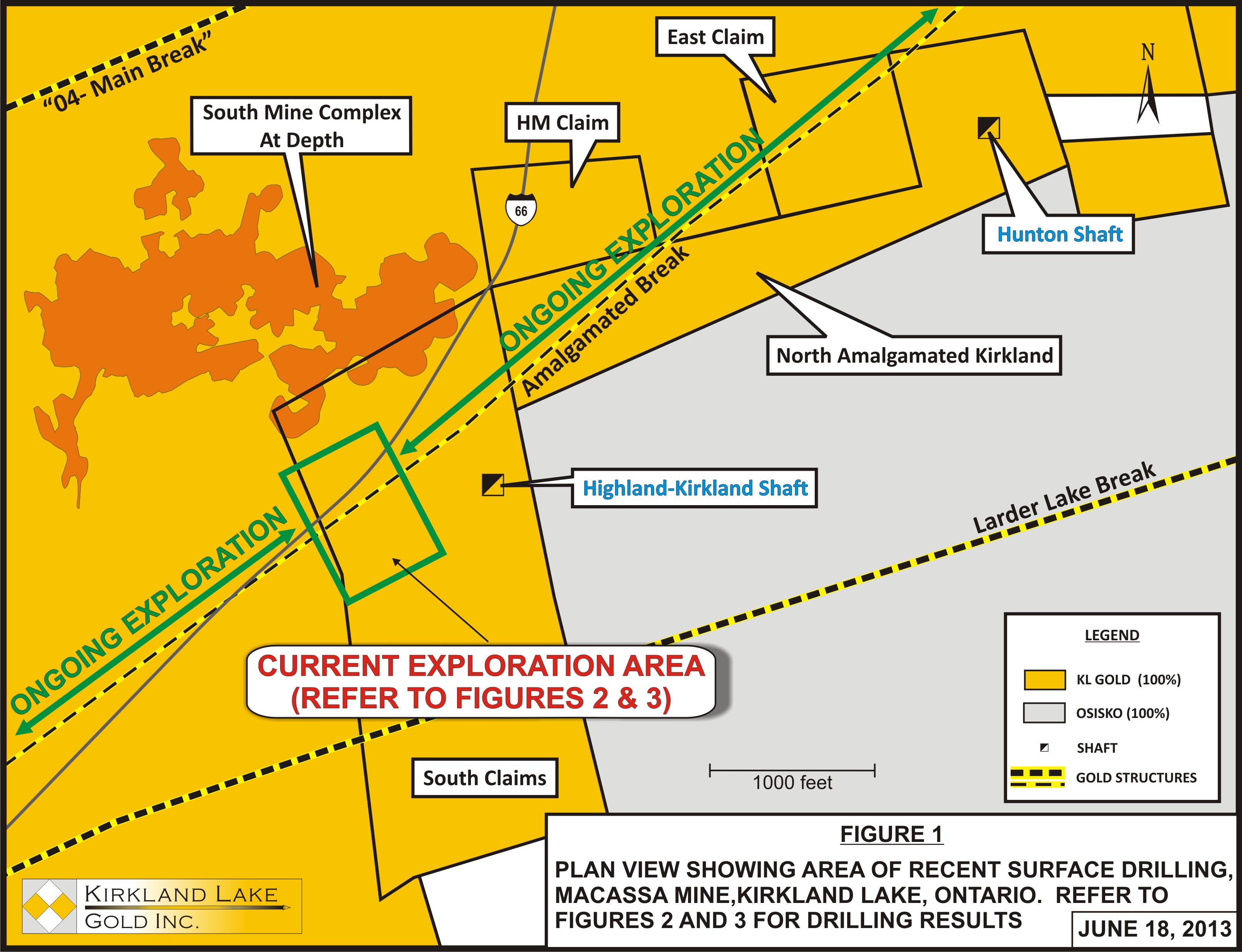
This first phase of the surface exploration program was designed to follow up on several high grade intercepts associated with the Amalgamated Break (see the Company's news releases dated February 28, 2012 and September 5, 2012) and to test for mineralization down to 1,000 feet below surface within the South Claims Property (See Figure 1). The Amalgamated Break has seen limited historic exploration east and west of the South Claims property and little historic drilling on this property.
Mr. Harry Dobson, Chairman commented, "We are very pleased with the results to date of this surface exploration program and are excited about the potential to add a reserve and resource calculation on ounces close to surface. The surface program will continue throughout the year as exploration continues both east and west from this area. It should be noted that none of the surface drilling results to date were included in our latest reserve and resource update."
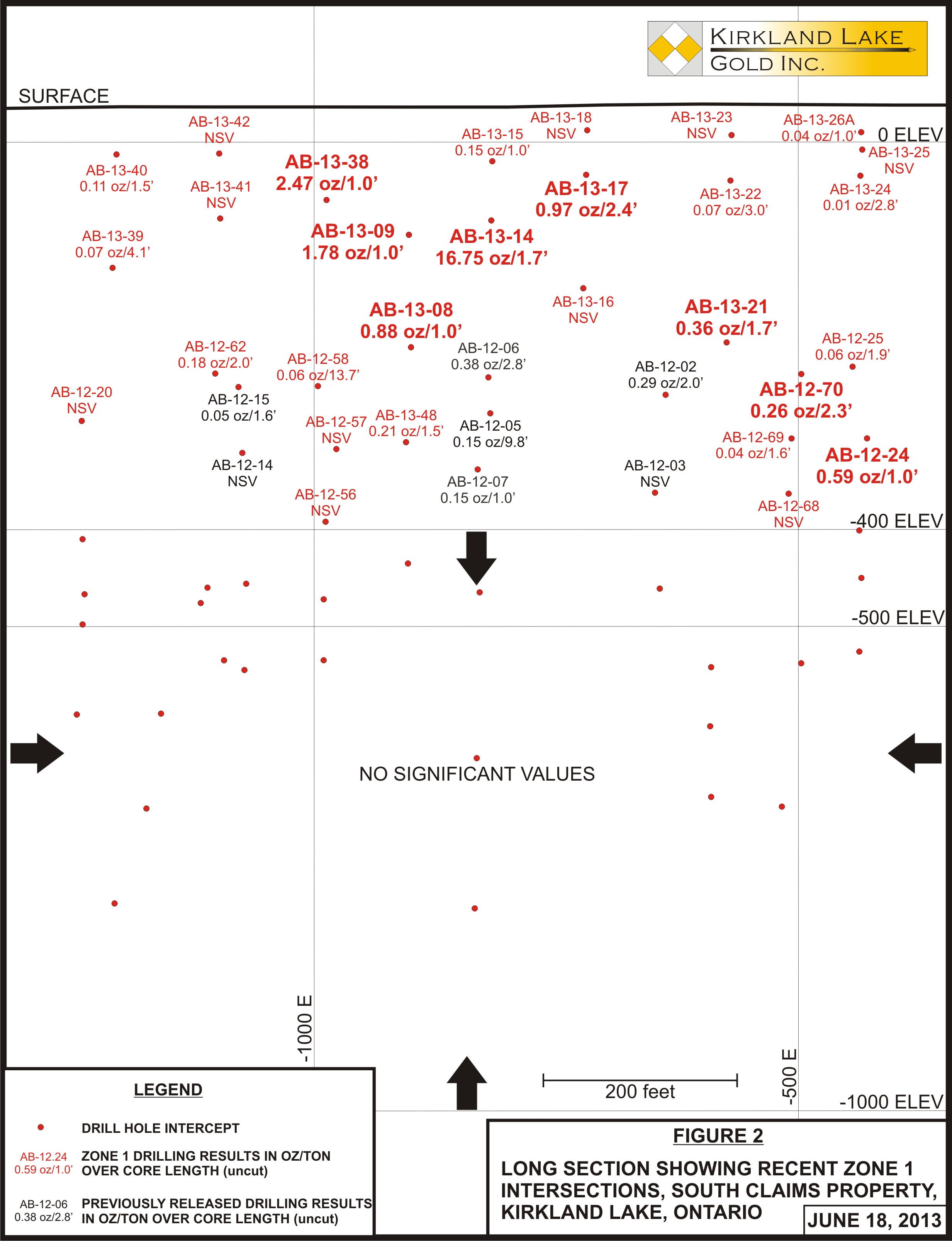
This initial phase of drilling has been successful in further validating and expanding two previously discovered mineralized zones (now Zone 1 and Zone 2) as well as intersecting various sporadic high grade zones, including 16.75 ounces of gold per ton (opt) over 0.8 feet true width. The strongest alteration and highest grade intercepts in the explored area were found to be less than 400 feet below surface, although the drilling did find that the alteration and weak mineralization did extend below this elevation (See Figures 2 and 3).
The following are some of the highlights of the current exploration program:
- Drill hole AB-13-14 intersected Zone 1 and returned 16.75 opt uncut over 1.0 foot of core length (0.8 feet true width). This intersection is only 117 feet below surface and contained significant visible gold.
- Drill hole AB-13-41 intersected Zone 2 and returned 4.68 opt uncut over 1.0 foot of core length (0.6 feet true width). This intersection is approximately 166 feet below surface and contained visible gold.
- Drill hole AB-13-10 intersected a new zone footwall to both Zone 1 and Zone 2 that returned 3.05 opt uncut over 1.0 foot of core length (true width unknown). This intersection is approximately 128 feet below surface and warrants follow-up drilling.
- Drill hole AB-13-17 intersected Zone 1 only 71 feet below surface and returned 0.97 opt over 2.4 feet of core length (1.5 feet true width) and represents one of the shallowest intersection to date on this zone.
This drill program is part of a much larger long term exploration initiative. The Company is currently operating three exploration drills on surface, two of which are exploring shallow targets and one that is drilling deeper grassroots targets. The mineralization in these zones is hosted primarily in sericitized sediments (generally greywacke) and is often characterized by broad zones of fine disseminated pyrite with or without narrow quartz stringers. The style of alteration and mineralization encountered appears to be different from that of both the '04 Break and SMC. The success of the first phase of this exploration program gives strong justification for the long term exploration plan to thoroughly explore this mineralized horizon east and west of the South Claims property across the Company's landholdings.
The following figures, referred to elsewhere in this release, may be viewed at the Company's website at www.klgold.com.
- Figure 1 - plan view showing current surface drill programs on the South Claims.
- Figure 2 - long section showing current Zone 1 intercepts.
- Figure 3 - long section showing current Zone 2 and New Zone intercepts.
The following tables summarize the latest drilling results in imperial values:
| SOUTH CLAIMS SURFACE EXPLORATION | |||||||
| DRILL HOLE No. |
ZONE | FROM (feet) |
TO (feet) |
HOLE DIP (degrees) |
AZIMUTH (degrees) |
ASSAY (oz per ton/feet) |
|
| AB-13-14 | Zone 1 Zone 2 |
130.0 225.5 |
131.7 226.5 |
-65 | 327 | 16.75/1.7' CL=0.8' TW, VG 0.84/1.0' CL=0.4' TW |
|
| AB-13-41 | Zone 1 Zone 2 |
174.3 |
175.3 |
-70 | 327 | NSV 4.68/1.0' CL=0.6' TW, VG |
|
| AB-13-10 | Zone 1 Zone 2 New Zone |
99.0 117.2 237.3 |
100.0 118.2 238.3 |
-45 | 314 | 0.02/1.0' CL=0.8' TW 0.58/1.0' CL=0.6' TW 3.05/1.0' CL=0.8' TW, VG |
|
| AB-13-17 | Zone 1 Zone 2 New Zone New Zone |
75.7 141.0 210.0 221.7 |
78.1 142.0 212.3 222.7 |
-70 | 327 | 0.97/2.4' CL=1.5' TW, VG 0.37/1.0' CL=0.7' TW, VG 0.34/2.3' CL=?? TW 0.28/1.0' CL=?? TW |
|
| AB-12-20 | -65 | 327 | NSV | ||||
| AB-12-21 | -80 | 327 | NSV | ||||
| AB-12-24 | Zone 1 Zone 2 |
400.3 454.3 |
401.3 455.3 |
-58 | 327 | 0.59/1.0' CL=1.0' TW, VG 0.03/1.0' CL=1.0'TW |
|
| AB-12-25 | Zone 1 Zone 2 |
384.1 448.6 |
386 449.6 |
-45 | 327 | 0.06/1.9' CL=1.9' TW 0.03/1.0' CL=1.0' TW |
|
| AB-12-57 | -59 | 327 | NSV | ||||
| AB-12-58 | Zone 1 Zone 2 |
413.3 486.8 |
427.0 488.8 |
-45 | 327 | 0.06/13.7' CL=13.1' TW 4.36/2.0' CL=1.9' TW |
|
| AB-12-62 | Zone 1 Zone 2 |
370.5 | 372.5 | -45 | 327 | 0.18/2.0' CL=1.8' TW NSV |
|
| AB-12-68 | Zone 1 Zone 2 |
456.0 |
459.0 |
-65 | 327 | NSV 0.09/3.0' CL=2.7' TW |
|
| AB-12-69 | Zone 1 Zone 2 |
396.5 438.8 |
398.1 441.0 |
-55 | 327 | 0.04/1.6' CL=1.5' TW 0.10/2.2' CL=2.1' TW |
|
| AB-12-70 | Zone 1 Zone 2 Incl. and and |
376.0 401.2 401.2 404.3 411.7 |
378.3 412.8 402.2 405.6 412.8 |
-45 | 327 | 0.26/2.3' CL=2.3' TW, VG 0.27/11.6' CL=11.5' TW, VG 0.70/1.0' CL=1.0' TW 0.90/1.3' CL=1.3' TW 0.93/1.1' CL=1.1' TW |
|
| AB-13-08 | Zone 1 Zone 2 |
256.3 296.7 |
257.3 301.2 |
-76 | 314 | 0.88/1.0' CL=0.3' TW, VG 0.32/4.5' CL=1.8' TW |
|
| AB-13-09 | Zone 1 Zone 2 |
148.5 241.4 |
149.5 242.4 |
-65 | 314 | 1.78/1.0' CL=0.5' TW, VG 4.14/1.0' CL=0.4' TW, VG |
|
| AB-13-15 | Zone 1 Zone 2 |
83.0 130.7 |
84.0 131.7 |
-45 | 327 | 0.15/1.0' CL=0.7' TW 1.93/1.0' CL=0.8' TW, VG |
|
| AB-13-16 | Zone 1 Zone 2 |
285.5 |
290.5 |
-88 | 327 | NSV 0.06/5.0' CL=2.9' TW |
|
| AB-13-18 | -45 | 327 | NSV | ||||
| AB-13-21 | Zone 1 Zone 2 |
247.8 281.2 |
249.5 284.0 |
-87 | 327 | 0.36/1.7' CL=0.6' TW, VG 1.00/2.8' CL=1.7' TW, VG |
|
| AB-13-22 | Zone 1 Zone 2 |
89.0 | 92.0 | -65 | 327 | 0.07/3.0' CL=1.4' TW NSV |
|
| AB-13-23 | Zone 1 Zone 2 |
125.8 |
128.0 |
-45 | 327 | NSV 0.03/2.2' CL=1.7' TW |
|
| AB-13-24 | Zone 1 Zone 2 |
44.8 | 47.0 | -84 | 327 | 0.01/2.2' CL=1.1' TW NSV |
|
| AB-13-25 | -60 | 327 | NSV | ||||
| AB-13-26A | Zone 1 Zone 2 |
36.5 90.8 |
37.5 91.8 |
-45 | 327 | 0.04/1.0' CL=0.7' TW 0.01/1.0' CL=0.9' TW |
|
| AB-13-38 | Zone 1 Zone 2 |
135.5 151.5 |
136.5 152.5 |
-45 | 327 | 2.47/1.0' CL=0.8' TW, VG 0.02/1.0' CL=0.6' TW |
|
| AB-13-39 | Zone 1 Zone 2 |
170.7 232.0 |
174.8 234.5 |
-73 | 327 | 0.07/4.1' CL=1.9' TW 0.06/2.5' CL=1.3' TW |
|
| AB-13-40 | Zone 1 Zone 2 |
65.5 141.2 |
67.0 142.2 |
-45 | 327 | 0.11/1.5' CL=1.2' TW 0.32/1.0' CL=0.8' TW |
|
| AB-13-42 | Zone 1 Zone 2 New Zone |
113.0 377.8 |
114.0 378.8 |
-45 | 327 | NSV 0.07/1.0' CL=0.9' TW 1.33/1.0' CL=?? TW, VG |
|
| AB-13-48 | New Zone Zone 1 Zone 2 |
94.3 430.3 |
100.0 431.8 |
-53 | 327 | 0.36/5.7' CL=?? TW 0.21/1.5' CL=1.4' TW NSV |
|
| TW = True Width, CL = Core Length, VG = Visible Gold, ?? TW = True Width Unknown, NSV = No Significant Values |
| All values in the above table are uncut values as a suitable cut factor for this area has yet to be determined. |
The following tables summarize the latest drilling results in metric values:
| SOUTH CLAIMS SURFACE EXPLORATION | ||||||||
| DRILL HOLE No. |
ZONE | FROM (m) |
TO (m) |
HOLE DIP (degrees) |
AZIMUTH (degrees) |
ASSAY (grams per tonne/m) |
||
| AB-13-14 | Zone 1 Zone 2 |
39.6 68.7 |
40.1 69.0 |
-65 | 327 | 574.29/0.5m CL=0.2m TW, VG 28.80/0.3m CL=0.1m TW |
||
| AB-13-41 | Zone 1 Zone 2 |
53.1 |
53.4 |
-70 | 327 | NSV 160.46/0.3m CL=0.2m TW, VG |
||
| AB-13-10 | Zone 1 Zone 2 New Zone |
30.2 35.7 72.3 |
30.5 36.0 72.6 |
-45 | 314 | 0.69/0.3m CL=0.8m TW 19.89/0.3m CL=0.2m TW 104.57/0.3m CL=0.2m TW, VG |
||
| AB-13-17 | Zone 1 Zone 2 New Zone New Zone |
23.1 43.0 64.0 67.6 |
23.8 43.3 64.7 67.9 |
-70 | 327 | 33.26/0.7m CL=0.5m TW, VG 12.69/0.3m CL=0.2m TW, VG 11.66/0.7m CL=?? TW 9.60/0.3m CL=?? TW |
||
| AB-12-20 | -65 | 327 | NSV | |||||
| AB-12-24 | Zone 1 Zone 2 |
122.0 138.5 |
122.3 138.8 |
-58 | 327 | 20.23/0.3m CL=0.3m TW, VG 1.03/0.3m CL=0.3m TW |
||
| AB-12-25 | Zone 1 Zone 2 |
117.1 136.7 |
117.7 137.0 |
-45 | 327 | 2.06/0.6m CL=0.6m TW 1.03/0.3m CL=0.3m TW |
||
| AB-12-57 | -59 | 327 | NSV | |||||
| AB-12-58 | Zone 1 Zone 2 |
126.0 148.4 |
130.1 149.0 |
-45 | 327 | 2.06/4.2m CL=4.0m TW 149.49/0.6m CL=0.6m TW |
||
| AB-12-62 | Zone 1 Zone 2 |
112.9 | 113.5 | -45 | 327 | 6.17/0.6m CL=0.5m TW NSV |
||
| AB-12-68 | Zone 1 Zone 2 |
139.0 |
139.9 |
-65 | 327 | NSV 3.09/0.9m CL=0.8m TW |
||
| AB-12-69 | Zone 1 Zone 2 |
120.9 133.7 |
121.3 134.4 |
-55 | 327 | 1.37/0.5m CL=0.5m TW 3.43/0.7m CL=0.6m TW |
||
| AB-12-70 | Zone 1 Zone 2 Incl. and and |
114.6 122.3 122.3 123.2 125.5 |
115.3 125.8 122.6 123.6 125.8 |
-45 | 327 | 8.91/0.7m CL=0.7m TW, VG 9.26/3.5m CL=3.5m TW, VG 24.00/0.3m CL=0.3m TW 30.86/0.4m CL=0.4m TW 31.89/0.3m CL=0.3m TW |
||
| AB-13-08 | Zone 1 Zone 2 |
78.1 90.4 |
78.4 91.8 |
-76 | 314 | 30.17/0.3m CL=0.1m TW, VG 10.97/1.4m CL=0.5m TW |
||
| AB-13-09 | Zone 1 Zone 2 |
45.3 73.6 |
45.6 73.9 |
-65 | 314 | 61.03/0.3m CL=0.2m TW, VG 141.94/0.3m CL=0.1m TW, VG |
||
| AB-13-15 | 25.3 39.8 |
25.6 40.1 |
-45 | 327 | 5.14/0.3m CL=0.2m TW 66.17/0.3m CL=0.2m TW, VG |
|||
| AB-13-16 | Zone 1 Zone 2 |
87.0 |
88.5 |
-88 | 327 | NSV 2.06/1.5m CL=0.9m TW |
||
| AB-13-18 | -45 | 327 | NSV | |||||
| AB-13-21 | Zone 1 Zone 2 |
75.5 85.7 |
76.0 86.6 |
-87 | 327 | 12.34/0.5m CL=0.2m TW, VG 34.29/0.9m CL=0.5m TW, VG |
||
| AB-13-22 | Zone 1 Zone 2 |
27.1 | 28.0 | -65 | 327 | 2.40/0.9m CL=0.4m TW NSV |
||
| AB-13-23 | Zone 1 Zone 2 |
38.3 |
39.0 |
-45 | 327 | NSV 1.03/0.7m CL=0.5m TW |
||
| AB-13-24 | Zone 1 Zone 2 |
13.7 | 14.3 | -84 | 327 | 0.34/0.7m CL=0.3m TW NSV |
||
| AB-13-25 | -60 | 327 | NSV | |||||
| AB-13-26A | Zone 1 Zone 2 |
11.1 27.7 |
11.4 28.0 |
-45 | 327 | 1.37/0.3m CL=0.2m TW 0.34/0.3m CL=0.3m TW |
||
| AB-13-38 | Zone 1 Zone 2 |
41.3 46.2 |
41.6 46.5 |
-45 | 327 | 84.69/0.3m CL=0.2m TW, VG 0.69/0.3m CL=0.2m TW |
||
| AB-13-39 | Zone 1 Zone 2 |
52.0 70.7 |
53.3 71.5 |
-73 | 327 | 2.40/1.2m CL=0.6m TW 2.06/0.8m CL=0.4m TW |
||
| AB-13-40 | Zone 1 Zone 2 |
20.0 43.0 |
20.4 43.3 |
-45 | 327 | 3.77/0.5m CL=0.4m TW 10.97/0.3m CL=0.2m TW |
||
| AB-13-42 | Zone 1 Zone 2 New Zone |
34.4 115.2 |
34.7 115.5 |
-45 | 327 | NSV 2.40/0.3m CL=0.3m TW 45.60/0.3m CL=?? TW, VG |
||
| AB-13-48 | New Zone Zone 1 Zone 2 |
28.7 131.2 |
30.5 131.6 |
-53 | 327 | 12.34/1.7m CL=?? TW 7.20/0.5m CL=0.4m TW NSV |
||
| TW = True Width, CL = Core Length, VG = Visible Gold, ?? TW = True Width Unknown, NSV = No Significant Values |
| All values in the above table are uncut values as a suitable cut factor for this area has yet to be determined. |
About the Company
Kirkland Lake Gold's corporate goal is to create a self sustaining and long lived intermediate gold mining company based in the historic Kirkland Lake Gold Camp. The Company plans to do this by increasing production capacity to 2,200 tons of ore per day in several stages, and by decreasing production costs by realizing the economies of scale associated with that higher production capacity. At the same time, the Company is committed to maintaining a significant exploration program aimed at developing and maintaining a property wide reserve and resource base sufficient to sustain a mine life of more than ten years for as long as practicable.
The results of the Company's underground diamond drilling program have been reviewed, verified (including sampling, analytical and test data) and compiled by the Company's geological staff (which includes a 'qualified person', Stewart Carmichael P.Geo., the Company's Chief Exploration Geologist, for the purpose of National Instrument 43-101, Standards of Disclosure for Mineral Projects, of the Canadian Securities Administrators). Mr. Carmichael also supervised the preparation of the information that forms the basis of the technical disclosure in this release.
The Company has implemented a quality assurance and control (QA/QC) program to ensure sampling and analysis of all exploration work is conducted in accordance with the best possible practices. The drill core is sawn in half with one half of the core samples shipped to Swastika Laboratories in Swastika, Ontario. The other half of the core is retained for future assay verification. Other QA/QC includes the insertion of blanks, and the regular re-assaying of pulps and rejects at alternate certified labs. Gold analysis is conducted by fire assay using atomic absorption or gravimetric finish. The laboratory re-assays at least 10% of all samples and additional checks may be run on anomalous values.
The Company's Macassa Mine Property is the subject of a reserve report prepared by Glenn R. Clark, P.Eng. entitled Review of Resources and Reserves of Macassa Mine, Kirkland Lake, Ontario at January 1, 2012 dated May 29, 2012, which has been filed on SEDAR (www.sedar.com) under the Company's filings.
To view Figure 1, please visit the following link: http://media3.marketwire.com/docs/kgi618f1.jpg
To view Figure 2, please visit the following link: http://media3.marketwire.com/docs/kgi618f2.jpg
To view Figure 3, please visit the following link: http://media3.marketwire.com/docs/kgi618f3.jpg
Cautionary Note Regarding Forward Looking Statements
This Press Release contains statements which constitute "forward-looking statements", including statements regarding the plans, intentions, beliefs and current expectations of the Company with respect to the future business activities and operating performance of the Company. The words "may", "would", "could", "will", "intend", "plan", "anticipate", "believe", "estimate", "expect" and similar expressions, as they relate to the Company, are intended to identify such forward-looking statements. Investors are cautioned that forward-looking statements are based on the opinions, assumptions and estimates of management considered reasonable at the date the statements are made, and are inherently subject to a variety of risks and uncertainties and other known and unknown factors that could cause actual events or results to differ materially from those projected in the forward-looking statements. These factors include the Company's expectations in connection with the projects and exploration programs being met, the impact of general business and economic conditions, global liquidity and credit availability on the timing of cash flows and the values of assets and liabilities based on projected future conditions, fluctuating gold prices, currency exchange rates (such as the Canadian dollar versus the United States Dollar), possible variations in ore grade or recovery rates, changes in accounting policies, changes in the Company's corporate mineral resources, changes in project parameters as plans continue to be refined, changes in project development, construction, production and commissioning time frames, risks related to joint venture operations, the possibility of project cost overruns or unanticipated costs and expenses, higher prices for fuel, power, labour and other consumables contributing to higher costs and general risks of the mining industry, failure of plant, equipment or processes to operate as anticipated, unexpected changes in mine life,, seasonality and unanticipated weather changes, costs and timing of the development of new deposits, success of exploration activities, permitting time lines, government regulation of mining operations, environmental risks, unanticipated reclamation expenses, title disputes or claims, and limitations on insurance, as well as those risk factors discussed or referred to in the Company's annual Management's Discussion and Analysis and Annual Information Form for the year ended April 30, 2012 filed with the securities regulatory authorities in certain provinces of Canada and available at www.sedar.com.
Should one or more of these risks or uncertainties materialize, or should assumptions underlying the forward-looking statements prove incorrect, actual results may vary materially from those described herein as intended, planned, anticipated, believed, estimated or expected. Although the Company has attempted to identify important risks, uncertainties and factors which could cause actual results to differ materially, there may be others that cause results not be as anticipated, estimated or intended. The Company does not intend, and does not assume any obligation, to update these forward-looking statements except as otherwise required by applicable law.
Neither the Toronto Stock Exchange nor the AIM Market of the London Stock Exchange has reviewed and neither accepts responsibility for the adequacy or accuracy of this news release.
Contact Information:
Brian Hinchcliffe
President
+1 705 567 5208
+1 705 568 6444 (FAX)
bhinchcliffe@klgold.com
Kirkland Lake Gold Inc.
Lindsay Carpenter
Director of Investor Relations
+1 416-840-7884
+1 705 568 6444 (FAX)
lcarpenter@klgold.com
www.klgold.com
NOMAD: Panmure Gordon (UK) Limited
Callum Stewart
+44 (0) 20 7 886 2500
callum.stewart@panmure.com
NOMAD: Panmure Gordon (UK) Limited
Adam James
+44 (0) 20 7 886 2500
adam.james@panmure.com